Gunung Kendil geodata
Gunung Kendil (Central Java) is a populated place; located in Indonesia in Asia/Jakarta (GMT+7) time zone. With population of 1,273 people, there are 400 cities with bigger population in this country. Compared to other cities in Indonesia, 50.3% of cities are located further ↑North; 65.5% of cities are located further →East and 99.1% of cities have lower elevation than Gunung Kendil. Note1


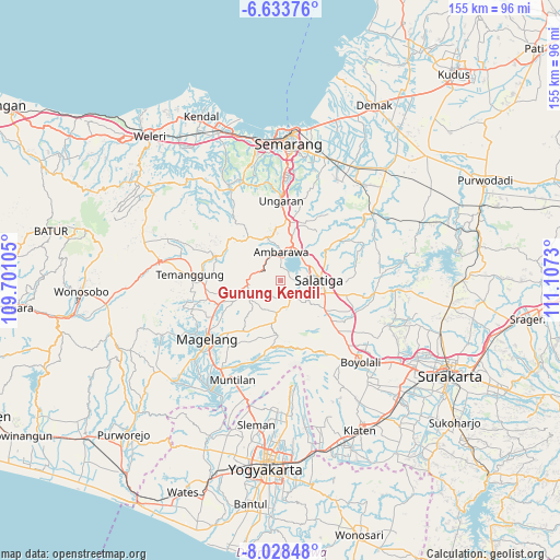
Gunung Kendil GPS coordinates[2]
7° 19' 54.012" South, 110° 24' 15.012" East
| Map corner | latitude | longitude |
|---|---|---|
| Upper-left | -6.63376°, | 109.70105° |
| Center: | -7.33167°, | 110.40417° |
| Lower-right: | -8.02848°, | 111.1073° |
| Map W x H: | 155.1×155.1 km | = 96.4×96.4mi |
| max Lat: | 5.88969° ⇑50.3% North |
| Gunung Kendil: | -7.33167° |
| min Lat: | ⇓49.7% South -10.934° |
| min Long | Gunung Kendil | max Long |
| 95.1345° | 110.40417° | 140.9419° |
| W 34.5%⇐ | ⇒65.5% E |
Elevation
Elevation of Gunung Kendil is 1234 m = 4049 ft, and this is 1004.3 m = 3295 ft above average elevation for this country.
| Max E: |
3185 m = 10449 ft | 0.90000000000001% |
| Gunung Kendil | 1234 m 4049 ft | |
| Avg. | 229.7 m = 754 ft | |
Min E: |
-1 m = -3 ft | 99.1% |
See also: Indonesia elevation on elevation.city.
Geographical zone
Gunung Kendil is located in South Torrid zone (between Equator and Tropic of Capricorn). Distance of Equator is 815.2 km =506.5 mi to North.| Distance of | km | miles | from Gunung Kendil |
|---|---|---|---|
| Equator | 815.2 | 506.5 | to North |
| Tropic Capricorn | 1790.7 | 1112.7 | to South |
| Antarctic Circle | 6586 | 4092.3 | to South |
| South Pole | 9191.9 | 5711.6 | to South |


Nearby cities:
15 places around Gunung Kendil: (largest is in red/bold)
• Ambarawa
7.6 km =4.7 mi,  354°
354°
• Boyolali
30.8 km =19.1 mi,  136°
136°
• Jogonalan
43.8 km =27.2 mi,  160°
160°
• Karanganom
42.9 km =26.7 mi,  145°
145°
• Magelang
25.7 km =16 mi,  233°
233°
• Mertoyudan
28.7 km =17.8 mi,  223°
223°
• Mranggen
36.1 km =22.4 mi,  19°
19°
• Mungkid
35.5 km =22.1 mi, 215°
• Muntilan
30.3 km =18.8 mi,  203°
203°
• Ngemplak
42.1 km =26.2 mi,  125°
125°
• Salatiga
9.8 km =6.1 mi,  90°
90°
• Semarang
37.7 km =23.4 mi,  2°
2°
• Sleman
43 km =26.7 mi,  187°
187°
• Temanggung
23.4 km =14.5 mi,  273°
273°
• Ungaran
21.3 km =13.2 mi, 0°
Sources, notices
• [Note1] Compared only with cities in Indonesia existing in our database
• [Src1] Map data: © OpenStreetMap contributors (CC-BY-SA)
• [Src2] Other city data from geonames.org with taken over terms of usage.
• [Src3] Geographical zone / Annual Mean Temperature by Robert A. Rohde @ Wikipedia
