Muaralembu geodata
Muaralembu (Riau) is a seat of a third-order administrative division; located in Indonesia in Asia/Jakarta (GMT+7) time zone. In our database, there are 407 cities with bigger population. Compared to other cities in Indonesia, 94.8% of cities are located further ↓South; 96.4% of cities are located further →East and 59.1% of cities have higher elevation than Muaralembu. Note1


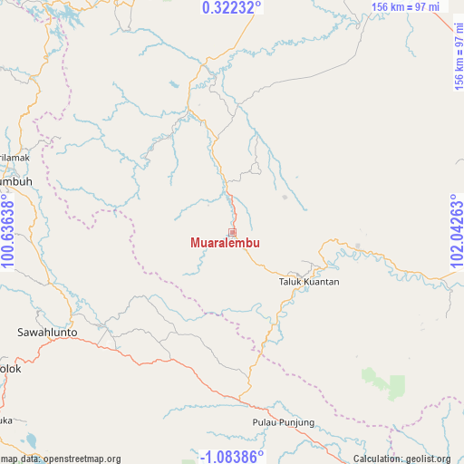
Muaralembu GPS coordinates[2]
0° 22' 50.88" South, 101° 20' 22.2" East
| Map corner | latitude | longitude |
|---|---|---|
| Upper-left | 0.32232°, | 100.63638° |
| Center: | -0.3808°, | 101.3395° |
| Lower-right: | -1.08386°, | 102.04263° |
| Map W x H: | 156.4×156.4 km | = 97.2×97.2mi |
| max Lat: | 5.88969° ⇑5.2% North |
| Muaralembu: | -0.3808° |
| min Lat: | ⇓94.8% South -10.934° |
| min Long | Muaralembu | max Long |
| 95.1345° | 101.3395° | 140.9419° |
| W 3.6%⇐ | ⇒96.4% E |
Elevation
Elevation of Muaralembu is 63 m = 207 ft, and this is 166.7 m = 547 ft below average elevation for this country.
| Max E: |
3185 m = 10449 ft | 59.1% |
| Avg. | 229.7 m = 754 ft | |
| Muaralembu | 63 m = 207 ft | |
Min E: |
-1 m = -3 ft | 40.9% |
See also: Indonesia elevation on elevation.city.
Geographical zone
Muaralembu is located in South Torrid zone (between Equator and Tropic of Capricorn). Distance of Equator is 42.3 km =26.3 mi to North.| Distance of | km | miles | from Muaralembu |
|---|---|---|---|
| Equator | 42.3 | 26.3 | to North |
| Tropic Capricorn | 2563.6 | 1592.9 | to South |
| Antarctic Circle | 7358.8 | 4572.5 | to South |
| South Pole | 9964.7 | 6191.8 | to South |


Nearby cities:
15 places around Muaralembu: (largest is in red/bold)
• Baserah
45.5 km =28.3 mi,  99°
99°
• Cerenti
60.6 km =37.7 mi, 103°
• Kototujuh
57.6 km =35.8 mi,  240°
240°
• Kumanis
59.6 km =37 mi,  251°
251°
• Lubukjambi
33.3 km =20.7 mi,  154°
154°
• Muaro
52.8 km =32.8 mi,  233°
233°
• Pulau Punjung
66.7 km =41.4 mi,  164°
164°
• Sijunjung
53.7 km =33.4 mi, 228°
• Sumpur Kudus
48.4 km =30.1 mi,  261°
261°
• Tanjung Mas
64.3 km =40 mi, 258°
• Tanjungampalu
63.2 km =39.3 mi, 244°
• Tanjungampalu
63.7 km =39.6 mi, 243°
• Tanjunggadang
46.9 km =29.1 mi,  199°
199°
• Tanjunggadang
67.4 km =41.9 mi,  277°
277°
• Teluk Kuantan
31.5 km =19.6 mi,  121°
121°
Sources, notices
• [Note1] Compared only with cities in Indonesia existing in our database
• [Src1] Map data: © OpenStreetMap contributors (CC-BY-SA)
• [Src2] Other city data from geonames.org with taken over terms of usage.
• [Src3] Geographical zone / Annual Mean Temperature by Robert A. Rohde @ Wikipedia
