Baserah geodata
Baserah (Riau) is a seat of a third-order administrative division; located in Indonesia in Asia/Jakarta (GMT+7) time zone. In our database, there are 407 cities with bigger population. Compared to other cities in Indonesia, 94.7% of cities are located further ↓South; 96.2% of cities are located further →East and 68.9% of cities have higher elevation than Baserah. Note1


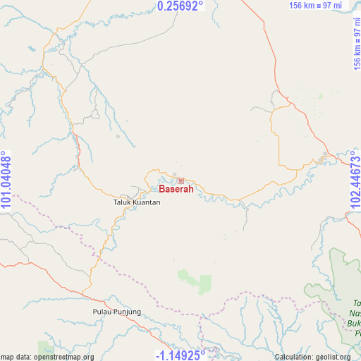
Baserah GPS coordinates[2]
0° 26' 46.32" South, 101° 44' 36.96" East
| Map corner | latitude | longitude |
|---|---|---|
| Upper-left | 0.25692°, | 101.04048° |
| Center: | -0.4462°, | 101.7436° |
| Lower-right: | -1.14925°, | 102.44673° |
| Map W x H: | 156.4×156.4 km | = 97.2×97.2mi |
| max Lat: | 5.88969° ⇑5.3% North |
| Baserah: | -0.4462° |
| min Lat: | ⇓94.7% South -10.934° |
| min Long | Baserah | max Long |
| 95.1345° | 101.7436° | 140.9419° |
| W 3.8%⇐ | ⇒96.2% E |
Elevation
Elevation of Baserah is 34 m = 112 ft, and this is 195.7 m = 642 ft below average elevation for this country.
| Max E: |
3185 m = 10449 ft | 68.9% |
| Avg. | 229.7 m = 754 ft | |
| Baserah | 34 m = 112 ft | |
Min E: |
-1 m = -3 ft | 31.1% |
See also: Indonesia elevation on elevation.city.
Geographical zone
Baserah is located in South Torrid zone (between Equator and Tropic of Capricorn). Distance of Equator is 49.6 km =30.8 mi to North.| Distance of | km | miles | from Baserah |
|---|---|---|---|
| Equator | 49.6 | 30.8 | to North |
| Tropic Capricorn | 2556.3 | 1588.4 | to South |
| Antarctic Circle | 7351.6 | 4568.1 | to South |
| South Pole | 9957.4 | 6187.2 | to South |


Nearby cities:
15 places around Baserah: (largest is in red/bold)
• Airmolek
61.6 km =38.3 mi,  82°
82°
• Cerenti
15.6 km =9.7 mi,  116°
116°
• Kotabaru
72.9 km =45.3 mi,  178°
178°
• Lubukjambi
38.2 km =23.7 mi,  233°
233°
• Muaralembu
45.5 km =28.3 mi,  279°
279°
• Muaro
90.6 km =56.3 mi,  254°
254°
• Pangkalan Kasai
73.6 km =45.7 mi,  102°
102°
• Pangkalanbunut
94.1 km =58.5 mi,  28°
28°
• Peranap
28.9 km =18 mi,  112°
112°
• Pulau Punjung
63.1 km =39.2 mi,  205°
205°
• Rengat
89.8 km =55.8 mi, 84°
• Sijunjung
89.8 km =55.8 mi, 251°
• Sumpur Kudus
92.8 km =57.7 mi,  270°
270°
• Tanjunggadang
71 km =44.1 mi,  238°
238°
• Teluk Kuantan
20.3 km =12.6 mi, 243°
Sources, notices
• [Note1] Compared only with cities in Indonesia existing in our database
• [Src1] Map data: © OpenStreetMap contributors (CC-BY-SA)
• [Src2] Other city data from geonames.org with taken over terms of usage.
• [Src3] Geographical zone / Annual Mean Temperature by Robert A. Rohde @ Wikipedia
