Teluk Kuantan geodata
Teluk Kuantan (Riau) is a seat of a second-order administrative division; located in Indonesia in Asia/Jakarta (GMT+7) time zone. In our database, there are 407 cities with bigger population. Compared to other cities in Indonesia, 94.5% of cities are located further ↓South; 96.2% of cities are located further →East and 61.3% of cities have higher elevation than Teluk Kuantan. Note1


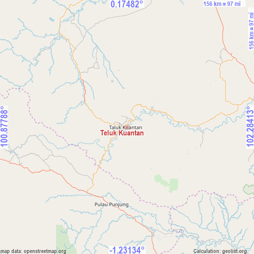
Teluk Kuantan GPS coordinates[2]
0° 31' 41.88" South, 101° 34' 51.6" East
| Map corner | latitude | longitude |
|---|---|---|
| Upper-left | 0.17482°, | 100.87788° |
| Center: | -0.5283°, | 101.581° |
| Lower-right: | -1.23134°, | 102.28413° |
| Map W x H: | 156.4×156.4 km | = 97.2×97.2mi |
| max Lat: | 5.88969° ⇑5.5% North |
| Teluk Kuantan: | -0.5283° |
| min Lat: | ⇓94.5% South -10.934° |
| min Long | Teluk Kuantan | max Long |
| 95.1345° | 101.581° | 140.9419° |
| W 3.8%⇐ | ⇒96.2% E |
Elevation
Elevation of Teluk Kuantan is 54 m = 177 ft, and this is 175.7 m = 576 ft below average elevation for this country.
| Max E: |
3185 m = 10449 ft | 61.3% |
| Avg. | 229.7 m = 754 ft | |
| Teluk Kuantan | 54 m = 177 ft | |
Min E: |
-1 m = -3 ft | 38.7% |
See also: Indonesia elevation on elevation.city.
Geographical zone
Teluk Kuantan is located in South Torrid zone (between Equator and Tropic of Capricorn). Distance of Equator is 58.7 km =36.5 mi to North.| Distance of | km | miles | from Teluk Kuantan |
|---|---|---|---|
| Equator | 58.7 | 36.5 | to North |
| Tropic Capricorn | 2547.2 | 1582.8 | to South |
| Antarctic Circle | 7342.4 | 4562.4 | to South |
| South Pole | 9948.3 | 6181.6 | to South |


Nearby cities:
15 places around Teluk Kuantan: (largest is in red/bold)
• Airmolek
81 km =50.3 mi,  77°
77°
• Baserah
20.3 km =12.6 mi,  63°
63°
• Cerenti
32.1 km =19.9 mi,  86°
86°
• Kotabaru
66.8 km =41.5 mi,  162°
162°
• Kototujuh
77.9 km =48.4 mi,  261°
261°
• Kumanis
83.4 km =51.8 mi,  268°
268°
• Lubukjambi
18.6 km =11.6 mi,  222°
222°
• Muaralembu
31.5 km =19.6 mi,  301°
301°
• Muaro
70.9 km =44.1 mi, 257°
• Peranap
44.8 km =27.8 mi, 92°
• Pulau Punjung
48.7 km =30.3 mi,  190°
190°
• Sijunjung
69.8 km =43.4 mi,  254°
254°
• Sumpur Kudus
75.4 km =46.9 mi,  277°
277°
• Tanjungampalu
84.6 km =52.6 mi, 261°
• Tanjunggadang
50.8 km =31.6 mi,  236°
236°
Sources, notices
• [Note1] Compared only with cities in Indonesia existing in our database
• [Src1] Map data: © OpenStreetMap contributors (CC-BY-SA)
• [Src2] Other city data from geonames.org with taken over terms of usage.
• [Src3] Geographical zone / Annual Mean Temperature by Robert A. Rohde @ Wikipedia
