Boroko geodata
Boroko (North Sulawesi) is a seat of a second-order administrative division; located in Indonesia in Asia/Makassar (GMT+8) time zone. In our database, there are 407 cities with bigger population. Compared to other cities in Indonesia, 96% of cities are located further ↓South; 91.6% of cities are located further ←West and 90.6% of cities have higher elevation than Boroko. Note1


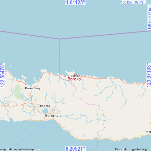
Boroko GPS coordinates[2]
0° 54' 29.88" North, 123° 16' 4.44" East
| Map corner | latitude | longitude |
|---|---|---|
| Upper-left | 1.61125°, | 122.56478° |
| Center: | 0.9083°, | 123.2679° |
| Lower-right: | 0.20521°, | 123.97103° |
| Map W x H: | 156.3×156.3 km | = 97.1×97.1mi |
| max Lat: | 5.88969° ⇑4% North |
| Boroko: | 0.9083° |
| min Lat: | ⇓96% South -10.934° |
| min Long | Boroko | max Long |
| 95.1345° | 123.2679° | 140.9419° |
| W 91.6%⇐ | ⇒8.4% E |
Elevation
Elevation of Boroko is 10 m = 33 ft, and this is 219.7 m = 721 ft below average elevation for this country.
| Max E: |
3185 m = 10449 ft | 90.6% |
| Avg. | 229.7 m = 754 ft | |
| Boroko | 10 m = 33 ft | |
Min E: |
-1 m = -3 ft | 9.4% |
See also: Indonesia elevation on elevation.city.
Geographical zone
Boroko is located in North Torrid zone (between Equator and Tropic of Cancer). Distance of Equator is 101 km =62.8 mi to South.| Distance of | km | miles | from Boroko |
|---|---|---|---|
| North Pole | 9906.1 | 6155.4 | to North |
| Arctic Circle | 7300.2 | 4536.1 | to North |
| Tropic Cancer | 2504.9 | 1556.5 | to North |
| Equator | 101 | 62.8 | to South |


Nearby cities:
15 places around Boroko: (largest is in red/bold)
• Bilungala
58.9 km =36.6 mi,  185°
185°
• Bolaang
98.8 km =61.4 mi,  87°
87°
• Bolangitang
4.3 km =2.7 mi, 92°
• Dumoga
96.5 km =60 mi,  110°
110°
• Gorontalo
47.1 km =29.3 mi,  208°
208°
• Isimu
53.9 km =33.5 mi,  237°
237°
• Kwandang
40.1 km =24.9 mi,  258°
258°
• Limboto
44.9 km =27.9 mi,  225°
225°
• Lolak
82.6 km =51.3 mi, 92°
• Molibagu
98.4 km =61.1 mi,  126°
126°
• Molobulahe
82.9 km =51.5 mi,  248°
248°
• Payunga
52 km =32.3 mi,  222°
222°
• Pimpi
31.5 km =19.6 mi,  95°
95°
• Sidomulyo
78.1 km =48.5 mi, 248°
• Suwawa
43.9 km =27.3 mi,  197°
197°
Sources, notices
• [Note1] Compared only with cities in Indonesia existing in our database
• [Src1] Map data: © OpenStreetMap contributors (CC-BY-SA)
• [Src2] Other city data from geonames.org with taken over terms of usage.
• [Src3] Geographical zone / Annual Mean Temperature by Robert A. Rohde @ Wikipedia
