Gorontalo geodata
Gorontalo is a seat of a first-order administrative division; located in Indonesia in Asia/Makassar (GMT+8) time zone. With population of 144,195 people, there are 81 cities with bigger population in this country. Compared to other cities in Indonesia, 95.5% of cities are located further ↓South; 90.5% of cities are located further ←West and 89% of cities have higher elevation than Gorontalo. Note1


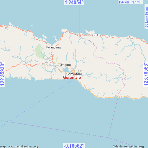
Gorontalo GPS coordinates[2]
0° 32' 15" North, 123° 3' 45" East
| Map corner | latitude | longitude |
|---|---|---|
| Upper-left | 1.24054°, | 122.35938° |
| Center: | 0.5375°, | 123.0625° |
| Lower-right: | -0.16562°, | 123.76563° |
| Map W x H: | 156.4×156.4 km | = 97.2×97.2mi |
| max Lat: | 5.88969° ⇑4.5% North |
| Gorontalo: | 0.5375° |
| min Lat: | ⇓95.5% South -10.934° |
| min Long | Gorontalo | max Long |
| 95.1345° | 123.0625° | 140.9419° |
| W 90.5%⇐ | ⇒9.5% E |
Elevation
Elevation of Gorontalo is 11 m = 36 ft, and this is 218.7 m = 718 ft below average elevation for this country.
| Max E: |
3185 m = 10449 ft | 89% |
| Avg. | 229.7 m = 754 ft | |
| Gorontalo | 11 m = 36 ft | |
Min E: |
-1 m = -3 ft | 11% |
See also: Gorontalo elevation on elevation.city.
Geographical zone
Gorontalo is located in North Torrid zone (between Equator and Tropic of Cancer). Distance of Equator is 59.8 km =37.2 mi to South.| Distance of | km | miles | from Gorontalo |
|---|---|---|---|
| North Pole | 9947.3 | 6181 | to North |
| Arctic Circle | 7341.4 | 4561.7 | to North |
| Tropic Cancer | 2546.2 | 1582.1 | to North |
| Equator | 59.8 | 37.2 | to South |


Nearby cities:
15 places around Gorontalo: (largest is in red/bold)
• Bilungala
24.1 km =15 mi,  135°
135°
• Bolangitang
49.2 km =30.6 mi,  33°
33°
• Boroko
47.1 km =29.3 mi, 28°
• Dumoga
113.7 km =70.6 mi,  85°
85°
• Isimu
25.3 km =15.7 mi,  298°
298°
• Kwandang
36.9 km =22.9 mi,  333°
333°
• Limboto
13.7 km =8.5 mi,  316°
316°
• Lolak
111.8 km =69.5 mi,  70°
70°
• Molibagu
103.7 km =64.4 mi,  99°
99°
• Molobulahe
55.2 km =34.3 mi,  281°
281°
• Payunga
12.6 km =7.8 mi, 283°
• Pimpi
66.4 km =41.3 mi,  54°
54°
• Sidomulyo
51.3 km =31.9 mi, 284°
• Suwawa
9.4 km =5.8 mi, 93°
• Tilamuta
79.6 km =49.5 mi,  269°
269°
Sources, notices
• [Note1] Compared only with cities in Indonesia existing in our database
• [Src1] Map data: © OpenStreetMap contributors (CC-BY-SA)
• [Src2] Other city data from geonames.org with taken over terms of usage.
• [Src3] Geographical zone / Annual Mean Temperature by Robert A. Rohde @ Wikipedia
