Muaralakitan geodata
Muaralakitan (South Sumatra) is a seat of a third-order administrative division; located in Indonesia in Asia/Jakarta (GMT+7) time zone. In our database, there are 407 cities with bigger population. Compared to other cities in Indonesia, 91.6% of cities are located further ↓South; 95.6% of cities are located further →East and 75.5% of cities have higher elevation than Muaralakitan. Note1


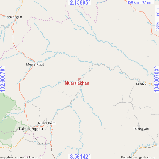
Muaralakitan GPS coordinates[2]
2° 51' 33.84" South, 103° 18' 14.04" East
| Map corner | latitude | longitude |
|---|---|---|
| Upper-left | -2.15695°, | 102.60078° |
| Center: | -2.8594°, | 103.3039° |
| Lower-right: | -3.56142°, | 104.00703° |
| Map W x H: | 156.2×156.2 km | = 97.1×97.1mi |
| max Lat: | 5.88969° ⇑8.4% North |
| Muaralakitan: | -2.8594° |
| min Lat: | ⇓91.6% South -10.934° |
| min Long | Muaralakitan | max Long |
| 95.1345° | 103.3039° | 140.9419° |
| W 4.4%⇐ | ⇒95.6% E |
Elevation
Elevation of Muaralakitan is 24 m = 79 ft, and this is 205.7 m = 675 ft below average elevation for this country.
| Max E: |
3185 m = 10449 ft | 75.5% |
| Avg. | 229.7 m = 754 ft | |
| Muaralakitan | 24 m = 79 ft | |
Min E: |
-1 m = -3 ft | 24.5% |
See also: Indonesia elevation on elevation.city.
Geographical zone
Muaralakitan is located in South Torrid zone (between Equator and Tropic of Capricorn). Distance of Equator is 317.9 km =197.5 mi to North.| Distance of | km | miles | from Muaralakitan |
|---|---|---|---|
| Equator | 317.9 | 197.5 | to North |
| Tropic Capricorn | 2288 | 1421.7 | to South |
| Antarctic Circle | 7083.2 | 4401.3 | to South |
| South Pole | 9689.1 | 6020.5 | to South |


Nearby cities:
15 places around Muaralakitan: (largest is in red/bold)
• Babat
39.7 km =24.7 mi,  70°
70°
• Bingintelok
33.5 km =20.8 mi,  321°
321°
• Gunungmegang Dalam
90.9 km =56.5 mi,  136°
136°
• Gunungmenang
88.5 km =55 mi,  113°
113°
• Lubuklinggau
69 km =42.9 mi,  225°
225°
• Muara Beliti
52.7 km =32.7 mi,  214°
214°
• Muaralimun
90 km =55.9 mi,  304°
304°
• Muararupit
46.2 km =28.7 mi,  289°
289°
• Padangulaktanding
80.1 km =49.8 mi,  224°
224°
• Sarolangun
88.4 km =54.9 mi,  313°
313°
• Sekayu
59 km =36.7 mi,  92°
92°
• Surulangun Rawas
65.5 km =40.7 mi, 293°
• Talang Ubi
73.4 km =45.6 mi,  127°
127°
• Tebing Tinggi
84.4 km =52.4 mi,  197°
197°
• Terawas
58.4 km =36.3 mi,  248°
248°
Sources, notices
• [Note1] Compared only with cities in Indonesia existing in our database
• [Src1] Map data: © OpenStreetMap contributors (CC-BY-SA)
• [Src2] Other city data from geonames.org with taken over terms of usage.
• [Src3] Geographical zone / Annual Mean Temperature by Robert A. Rohde @ Wikipedia
