Letung geodata
Letung (Riau Islands) is a seat of a third-order administrative division; located in Indonesia in Asia/Jakarta (GMT+7) time zone. In our database, there are 407 cities with bigger population. Compared to other cities in Indonesia, 98% of cities are located further ↓South; 93.9% of cities are located further →East and 99.7% of cities have higher elevation than Letung. Note1


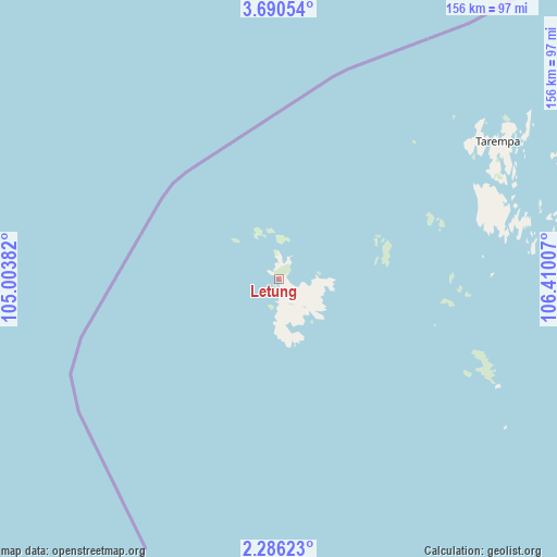
Letung GPS coordinates[2]
2° 59' 18.996" North, 105° 42' 24.984" East
| Map corner | latitude | longitude |
|---|---|---|
| Upper-left | 3.69054°, | 105.00382° |
| Center: | 2.98861°, | 105.70694° |
| Lower-right: | 2.28623°, | 106.41007° |
| Map W x H: | 156.1×156.1 km | = 97×97mi |
| max Lat: | 5.88969° ⇑2% North |
| Letung: | 2.98861° |
| min Lat: | ⇓98% South -10.934° |
| min Long | Letung | max Long |
| 95.1345° | 105.70694° | 140.9419° |
| W 6.1%⇐ | ⇒93.9% E |
Elevation
Elevation of Letung is 2 m = 7 ft, and this is 227.7 m = 747 ft below average elevation for this country.
| Max E: |
3185 m = 10449 ft | 99.7% |
| Avg. | 229.7 m = 754 ft | |
| Letung | 2 m = 7 ft | |
Min E: |
-1 m = -3 ft | 0.3% |
See also: Indonesia elevation on elevation.city.
Geographical zone
Letung is located in North Torrid zone (between Equator and Tropic of Cancer). Distance of Equator is 332.3 km =206.5 mi to South.| Distance of | km | miles | from Letung |
|---|---|---|---|
| North Pole | 9674.8 | 6011.6 | to North |
| Arctic Circle | 7068.9 | 4392.4 | to North |
| Tropic Cancer | 2273.6 | 1412.7 | to North |
| Equator | 332.3 | 206.5 | to South |


Nearby cities:
15 places around Letung: (largest is in red/bold)
• Bandar Seri Bentan
254.7 km =158.3 mi,  212°
212°
• Batam
277 km =172.1 mi,  222°
222°
• Belakangpadang
287.2 km =178.5 mi, 224°
• Cemaga
308 km =191.4 mi,  73°
73°
• Harapan Jaya
304.5 km =189.2 mi, 71°
• Kelarik
278.5 km =173.1 mi, 65°
• Kijang
261.1 km =162.2 mi, 207°
• Matak
76.2 km =47.3 mi,  58°
58°
• Pancur Biru Lestari II
284.7 km =176.9 mi, 220°
• Sabang Barat
227.3 km =141.2 mi,  89°
89°
• Sabang Mawang Barat
276.6 km =171.9 mi, 74°
• Sedanau
272.9 km =169.6 mi, 70°
• Sekupang
286.3 km =177.9 mi, 223°
• Tanjung Pinang
268.9 km =167.1 mi, 211°
• Tarempa
62 km =38.5 mi, 65°
Sources, notices
• [Note1] Compared only with cities in Indonesia existing in our database
• [Src1] Map data: © OpenStreetMap contributors (CC-BY-SA)
• [Src2] Other city data from geonames.org with taken over terms of usage.
• [Src3] Geographical zone / Annual Mean Temperature by Robert A. Rohde @ Wikipedia
