Kota Pinang geodata
Kota Pinang (North Sumatra) is a seat of a second-order administrative division; located in Indonesia in Asia/Jakarta (GMT+7) time zone. In our database, there are 407 cities with bigger population. Compared to other cities in Indonesia, 97% of cities are located further ↓South; 97.3% of cities are located further →East and 76.2% of cities have higher elevation than Kota Pinang. Note1


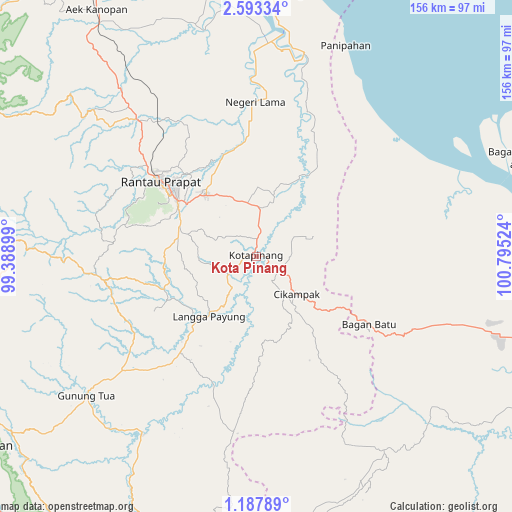
Kota Pinang GPS coordinates[2]
1° 53' 26.736" North, 100° 5' 31.596" East
| Map corner | latitude | longitude |
|---|---|---|
| Upper-left | 2.59334°, | 99.38899° |
| Center: | 1.89076°, | 100.09211° |
| Lower-right: | 1.18789°, | 100.79524° |
| Map W x H: | 156.3×156.3 km | = 97.1×97.1mi |
| max Lat: | 5.88969° ⇑3% North |
| Kota Pinang: | 1.89076° |
| min Lat: | ⇓97% South -10.934° |
| min Long | Kota Pinang | max Long |
| 95.1345° | 100.09211° | 140.9419° |
| W 2.7%⇐ | ⇒97.3% E |
Elevation
Elevation of Kota Pinang is 23 m = 75 ft, and this is 206.7 m = 678 ft below average elevation for this country.
| Max E: |
3185 m = 10449 ft | 76.2% |
| Avg. | 229.7 m = 754 ft | |
| Kota Pinang | 23 m = 75 ft | |
Min E: |
-1 m = -3 ft | 23.8% |
See also: Indonesia elevation on elevation.city.
Geographical zone
Kota Pinang is located in North Torrid zone (between Equator and Tropic of Cancer). Distance of Equator is 210.2 km =130.6 mi to South.| Distance of | km | miles | from Kota Pinang |
|---|---|---|---|
| North Pole | 9796.8 | 6087.4 | to North |
| Arctic Circle | 7190.9 | 4468.2 | to North |
| Tropic Cancer | 2395.7 | 1488.6 | to North |
| Equator | 210.2 | 130.6 | to South |


Nearby cities:
15 places around Kota Pinang: (largest is in red/bold)
• Bandar
41.9 km =26 mi,  294°
294°
• Binanga
64 km =39.8 mi,  213°
213°
• Langgapayung
23.2 km =14.4 mi,  218°
218°
• Panyabungan
44.8 km =27.8 mi,  275°
275°
• Paritjunus
58.8 km =36.5 mi,  70°
70°
• Paritkalipatopah
63.2 km =39.3 mi,  76°
76°
• Rantau Prapat
49.3 km =30.6 mi,  354°
354°
• Rantaupanjangkiri
62.6 km =38.9 mi, 73°
• Rantauprapat
37 km =23 mi,  308°
308°
• Simpangbandung
58.5 km =36.4 mi, 69°
• Simpangpasir
59.5 km =37 mi, 69°
• Sipiongot
48.1 km =29.9 mi,  262°
262°
• Sungaimaja
62.9 km =39.1 mi, 74°
• Sungaisegajah
64.3 km =40 mi, 71°
• Tanjunglumbalumba
65.8 km =40.9 mi, 70°
Sources, notices
• [Note1] Compared only with cities in Indonesia existing in our database
• [Src1] Map data: © OpenStreetMap contributors (CC-BY-SA)
• [Src2] Other city data from geonames.org with taken over terms of usage.
• [Src3] Geographical zone / Annual Mean Temperature by Robert A. Rohde @ Wikipedia
