Rantauprapat geodata
Rantauprapat (North Sumatra) is a populated place; located in Indonesia in Asia/Jakarta (GMT+7) time zone. With population of 103,009 people, there are 126 cities with bigger population in this country. Compared to other cities in Indonesia, 97.2% of cities are located further ↓South; 97.5% of cities are located further →East and 71.9% of cities have higher elevation than Rantauprapat. Note1


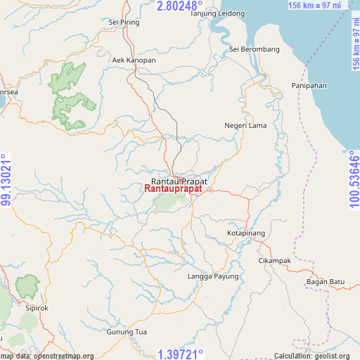
Rantauprapat GPS coordinates[2]
2° 6' 0" North, 99° 49' 59.988" East
| Map corner | latitude | longitude |
|---|---|---|
| Upper-left | 2.80248°, | 99.13021° |
| Center: | 2.1°, | 99.83333° |
| Lower-right: | 1.39721°, | 100.53646° |
| Map W x H: | 156.3×156.3 km | = 97.1×97.1mi |
| max Lat: | 5.88969° ⇑2.8% North |
| Rantauprapat: | 2.1° |
| min Lat: | ⇓97.2% South -10.934° |
| min Long | Rantauprapat | max Long |
| 95.1345° | 99.83333° | 140.9419° |
| W 2.5%⇐ | ⇒97.5% E |
Elevation
Elevation of Rantauprapat is 29 m = 95 ft, and this is 200.7 m = 658 ft below average elevation for this country.
| Max E: |
3185 m = 10449 ft | 71.9% |
| Avg. | 229.7 m = 754 ft | |
| Rantauprapat | 29 m = 95 ft | |
Min E: |
-1 m = -3 ft | 28.1% |
See also: Rantauprapat elevation on elevation.city.
Geographical zone
Rantauprapat is located in North Torrid zone (between Equator and Tropic of Cancer). Distance of Equator is 233.5 km =145.1 mi to South.| Distance of | km | miles | from Rantauprapat |
|---|---|---|---|
| North Pole | 9773.6 | 6073 | to North |
| Arctic Circle | 7167.7 | 4453.8 | to North |
| Tropic Cancer | 2372.4 | 1474.1 | to North |
| Equator | 233.5 | 145.1 | to South |


Nearby cities:
15 places around Rantauprapat: (largest is in red/bold)
• Aek Kanopan
56 km =34.8 mi,  339°
339°
• Bandar
10.8 km =6.7 mi,  239°
239°
• Binanga
77 km =47.8 mi,  184°
184°
• Gunung Tua
69.2 km =43 mi,  199°
199°
• Kota Pinang
37 km =23 mi,  128°
128°
• Langgapayung
43.9 km =27.3 mi,  160°
160°
• Panyabungan
24.5 km =15.2 mi,  220°
220°
• Paritjunus
84.2 km =52.3 mi,  92°
92°
• Rantau Prapat
35.4 km =22 mi,  43°
43°
• Sarulla
87.3 km =54.2 mi,  246°
246°
• Simpangbandung
83.6 km =51.9 mi, 92°
• Simpangpasir
84.3 km =52.4 mi, 91°
• Sipagimbar
59.4 km =36.9 mi, 239°
• Sipiongot
35 km =21.7 mi,  212°
212°
• Sipirok
83.2 km =51.7 mi,  228°
228°
Sources, notices
• [Note1] Compared only with cities in Indonesia existing in our database
• [Src1] Map data: © OpenStreetMap contributors (CC-BY-SA)
• [Src2] Other city data from geonames.org with taken over terms of usage.
• [Src3] Geographical zone / Annual Mean Temperature by Robert A. Rohde @ Wikipedia
