Bandar geodata
Bandar (North Sumatra) is a populated place; located in Indonesia in Asia/Jakarta (GMT+7) time zone. With population of 31,442 people, there are 308 cities with bigger population in this country. Compared to other cities in Indonesia, 97.1% of cities are located further ↓South; 97.5% of cities are located further →East and 56.9% of cities have higher elevation than Bandar. Note1


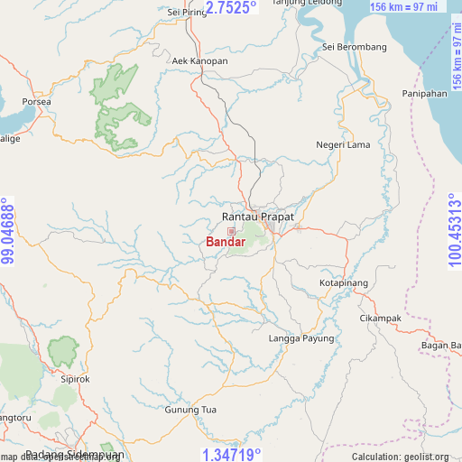
Bandar GPS coordinates[2]
2° 3' 0" North, 99° 45' 0" East
| Map corner | latitude | longitude |
|---|---|---|
| Upper-left | 2.7525°, | 99.04688° |
| Center: | 2.05°, | 99.75° |
| Lower-right: | 1.34719°, | 100.45313° |
| Map W x H: | 156.3×156.3 km | = 97.1×97.1mi |
| max Lat: | 5.88969° ⇑2.9% North |
| Bandar: | 2.05° |
| min Lat: | ⇓97.1% South -10.934° |
| min Long | Bandar | max Long |
| 95.1345° | 99.75° | 140.9419° |
| W 2.5%⇐ | ⇒97.5% E |
Elevation
Elevation of Bandar is 73 m = 240 ft, and this is 156.7 m = 514 ft below average elevation for this country.
| Max E: |
3185 m = 10449 ft | 56.9% |
| Avg. | 229.7 m = 754 ft | |
| Bandar | 73 m = 240 ft | |
Min E: |
-1 m = -3 ft | 43.1% |
See also: Indonesia elevation on elevation.city.
Geographical zone
Bandar is located in North Torrid zone (between Equator and Tropic of Cancer). Distance of Equator is 227.9 km =141.6 mi to South.| Distance of | km | miles | from Bandar |
|---|---|---|---|
| North Pole | 9779.1 | 6076.4 | to North |
| Arctic Circle | 7173.2 | 4457.2 | to North |
| Tropic Cancer | 2378 | 1477.6 | to North |
| Equator | 227.9 | 141.6 | to South |


Nearby cities:
15 places around Bandar: (largest is in red/bold)
• Aek Kanopan
58.8 km =36.5 mi,  349°
349°
• Balige
82.3 km =51.1 mi,  292°
292°
• Binanga
71.2 km =44.2 mi,  177°
177°
• Gunung Tua
61.3 km =38.1 mi,  192°
192°
• Kota Pinang
41.9 km =26 mi,  114°
114°
• Langgapayung
43 km =26.7 mi,  146°
146°
• Panyabungan
14.7 km =9.1 mi,  206°
206°
• Rantau Prapat
45.9 km =28.5 mi,  46°
46°
• Rantauprapat
10.8 km =6.7 mi,  59°
59°
• Sampuran
87.2 km =54.2 mi,  266°
266°
• Sarulla
76.6 km =47.6 mi,  247°
247°
• Sipagimbar
48.6 km =30.2 mi,  239°
239°
• Sipiongot
25.8 km =16 mi,  202°
202°
• Sipirok
72.6 km =45.1 mi,  226°
226°
• Tarutung
87.3 km =54.2 mi, 267°
Sources, notices
• [Note1] Compared only with cities in Indonesia existing in our database
• [Src1] Map data: © OpenStreetMap contributors (CC-BY-SA)
• [Src2] Other city data from geonames.org with taken over terms of usage.
• [Src3] Geographical zone / Annual Mean Temperature by Robert A. Rohde @ Wikipedia
