Rantau Prapat geodata
Rantau Prapat (North Sumatra) is a seat of a second-order administrative division; located in Indonesia in Asia/Jakarta (GMT+7) time zone. In our database, there are 407 cities with bigger population. Compared to other cities in Indonesia, 97.4% of cities are located further ↓South; 97.4% of cities are located further →East and 90.6% of cities have higher elevation than Rantau Prapat. Note1


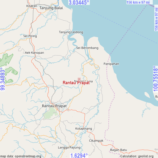
Rantau Prapat GPS coordinates[2]
2° 19' 55.56" North, 100° 3' 7.38" East
| Map corner | latitude | longitude |
|---|---|---|
| Upper-left | 3.03445°, | 99.34893° |
| Center: | 2.3321°, | 100.05205° |
| Lower-right: | 1.6294°, | 100.75518° |
| Map W x H: | 156.2×156.2 km | = 97.1×97.1mi |
| max Lat: | 5.88969° ⇑2.6% North |
| Rantau Prapat: | 2.3321° |
| min Lat: | ⇓97.4% South -10.934° |
| min Long | Rantau Prapat | max Long |
| 95.1345° | 100.05205° | 140.9419° |
| W 2.6%⇐ | ⇒97.4% E |
Elevation
Elevation of Rantau Prapat is 10 m = 33 ft, and this is 219.7 m = 721 ft below average elevation for this country.
| Max E: |
3185 m = 10449 ft | 90.6% |
| Avg. | 229.7 m = 754 ft | |
| Rantau Prapat | 10 m = 33 ft | |
Min E: |
-1 m = -3 ft | 9.4% |
See also: Indonesia elevation on elevation.city.
Geographical zone
Rantau Prapat is located in North Torrid zone (between Equator and Tropic of Cancer). Distance of Equator is 259.3 km =161.1 mi to South.| Distance of | km | miles | from Rantau Prapat |
|---|---|---|---|
| North Pole | 9747.8 | 6057 | to North |
| Arctic Circle | 7141.9 | 4437.8 | to North |
| Tropic Cancer | 2346.6 | 1458.1 | to North |
| Equator | 259.3 | 161.1 | to South |


Nearby cities:
15 places around Rantau Prapat: (largest is in red/bold)
• Aek Kanopan
51.6 km =32.1 mi,  300°
300°
• Bandar
45.9 km =28.5 mi,  226°
226°
• Kota Pinang
49.3 km =30.6 mi,  174°
174°
• Langgapayung
68 km =42.3 mi,  188°
188°
• Panyabungan
59.9 km =37.2 mi,  222°
222°
• Paritjunus
66.7 km =41.4 mi,  116°
116°
• Paritkalipatopah
74.5 km =46.3 mi, 117°
• Rantaupanjangkiri
71.7 km =44.6 mi, 115°
• Rantauprapat
35.4 km =22 mi, 223°
• Simpangbandung
65.9 km =40.9 mi, 115°
• Simpangpasir
66.1 km =41.1 mi,  114°
114°
• Sipiongot
70.2 km =43.6 mi, 218°
• Sungaimaja
72.9 km =45.3 mi, 116°
• Sungaisegajah
71.6 km =44.5 mi, 113°
• Tanjunglumbalumba
71.8 km =44.6 mi, 112°
Sources, notices
• [Note1] Compared only with cities in Indonesia existing in our database
• [Src1] Map data: © OpenStreetMap contributors (CC-BY-SA)
• [Src2] Other city data from geonames.org with taken over terms of usage.
• [Src3] Geographical zone / Annual Mean Temperature by Robert A. Rohde @ Wikipedia
