Kedungwuni geodata
Kedungwuni (Central Java) is a populated place; located in Indonesia in Asia/Jakarta (GMT+7) time zone. With population of 117,249 people, there are 112 cities with bigger population in this country. Compared to other cities in Indonesia, 68.4% of cities are located further ↓South; 65.8% of cities are located further →East and 81.9% of cities have higher elevation than Kedungwuni. Note1


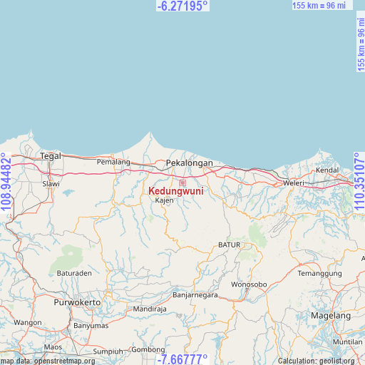
Kedungwuni GPS coordinates[2]
6° 58' 13.368" South, 109° 38' 52.584" East
| Map corner | latitude | longitude |
|---|---|---|
| Upper-left | -6.27195°, | 108.94482° |
| Center: | -6.97038°, | 109.64794° |
| Lower-right: | -7.66777°, | 110.35107° |
| Map W x H: | 155.2×155.2 km | = 96.4×96.4mi |
| max Lat: | 5.88969° ⇑31.6% North |
| Kedungwuni: | -6.97038° |
| min Lat: | ⇓68.4% South -10.934° |
| min Long | Kedungwuni | max Long |
| 95.1345° | 109.64794° | 140.9419° |
| W 34.2%⇐ | ⇒65.8% E |
Elevation
Elevation of Kedungwuni is 17 m = 56 ft, and this is 212.7 m = 698 ft below average elevation for this country.
| Max E: |
3185 m = 10449 ft | 81.9% |
| Avg. | 229.7 m = 754 ft | |
| Kedungwuni | 17 m = 56 ft | |
Min E: |
-1 m = -3 ft | 18.1% |
See also: Kedungwuni elevation on elevation.city.
Geographical zone
Kedungwuni is located in South Torrid zone (between Equator and Tropic of Capricorn). Distance of Equator is 775 km =481.6 mi to North.| Distance of | km | miles | from Kedungwuni |
|---|---|---|---|
| Equator | 775 | 481.6 | to North |
| Tropic Capricorn | 1830.9 | 1137.7 | to South |
| Antarctic Circle | 6626.1 | 4117.3 | to South |
| South Pole | 9232 | 5736.5 | to South |


Nearby cities:
15 places around Kedungwuni: (largest is in red/bold)
• Banjarnegara
47.6 km =29.6 mi,  173°
173°
• Batang
11.4 km =7.1 mi,  52°
52°
• Buaran
14 km =8.7 mi,  230°
230°
• Comal
14.4 km =8.9 mi,  300°
300°
• Kajen
10.4 km =6.5 mi, 228°
• Pekalongan
9.6 km =6 mi,  18°
18°
• Pemalang
30.6 km =19 mi,  286°
286°
• Purbalingga
56 km =34.8 mi,  214°
214°
• Randudongkal
38.4 km =23.9 mi,  248°
248°
• Slawi
56 km =34.8 mi,  268°
268°
• Tarub
53.3 km =33.1 mi, 274°
• Weleri
46.2 km =28.7 mi,  90°
90°
• Wiradesa
9.3 km =5.8 mi,  339°
339°
• Wonopringgo
3.7 km =2.3 mi, 247°
• Wonosobo
51.6 km =32.1 mi,  146°
146°
Sources, notices
• [Note1] Compared only with cities in Indonesia existing in our database
• [Src1] Map data: © OpenStreetMap contributors (CC-BY-SA)
• [Src2] Other city data from geonames.org with taken over terms of usage.
• [Src3] Geographical zone / Annual Mean Temperature by Robert A. Rohde @ Wikipedia
