Wiradesa geodata
Wiradesa (Central Java) is a populated place; located in Indonesia in Asia/Jakarta (GMT+7) time zone. With population of 39,407 people, there are 273 cities with bigger population in this country. Compared to other cities in Indonesia, 73.3% of cities are located further ↓South; 65.9% of cities are located further →East and 90.6% of cities have higher elevation than Wiradesa. Note1


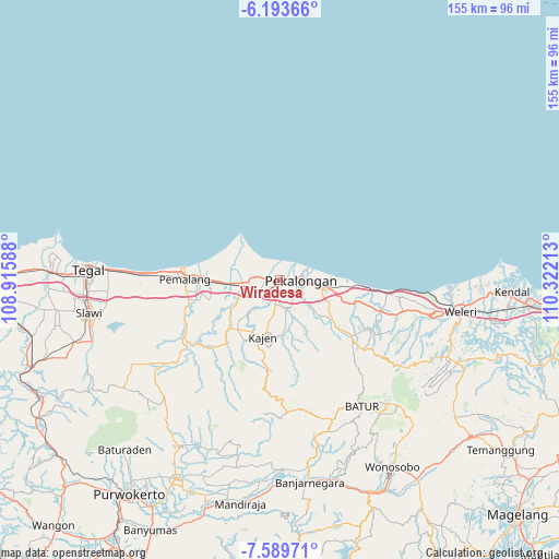
Wiradesa GPS coordinates[2]
6° 53' 31.92" South, 109° 37' 8.4" East
| Map corner | latitude | longitude |
|---|---|---|
| Upper-left | -6.19366°, | 108.91588° |
| Center: | -6.8922°, | 109.619° |
| Lower-right: | -7.58971°, | 110.32213° |
| Map W x H: | 155.2×155.2 km | = 96.4×96.4mi |
| max Lat: | 5.88969° ⇑26.7% North |
| Wiradesa: | -6.8922° |
| min Lat: | ⇓73.3% South -10.934° |
| min Long | Wiradesa | max Long |
| 95.1345° | 109.619° | 140.9419° |
| W 34.1%⇐ | ⇒65.9% E |
Elevation
Elevation of Wiradesa is 10 m = 33 ft, and this is 219.7 m = 721 ft below average elevation for this country.
| Max E: |
3185 m = 10449 ft | 90.6% |
| Avg. | 229.7 m = 754 ft | |
| Wiradesa | 10 m = 33 ft | |
Min E: |
-1 m = -3 ft | 9.4% |
See also: Indonesia elevation on elevation.city.
Geographical zone
Wiradesa is located in South Torrid zone (between Equator and Tropic of Capricorn). Distance of Equator is 766.3 km =476.2 mi to North.| Distance of | km | miles | from Wiradesa |
|---|---|---|---|
| Equator | 766.3 | 476.2 | to North |
| Tropic Capricorn | 1839.6 | 1143.1 | to South |
| Antarctic Circle | 6634.8 | 4122.7 | to South |
| South Pole | 9240.7 | 5741.9 | to South |


Nearby cities:
15 places around Wiradesa: (largest is in red/bold)
• Adiwerna
53.9 km =33.5 mi,  264°
264°
• Batang
12.4 km =7.7 mi,  98°
98°
• Buaran
19.1 km =11.9 mi,  203°
203°
• Comal
9.4 km =5.8 mi, 261°
• Kajen
16.3 km =10.1 mi, 196°
• Kedungwuni
9.3 km =5.8 mi,  159°
159°
• Lebaksiu
55.3 km =34.4 mi,  251°
251°
• Pekalongan
6.2 km =3.9 mi,  86°
86°
• Pemalang
26.1 km =16.2 mi,  270°
270°
• Randudongkal
39.8 km =24.7 mi,  234°
234°
• Slawi
53.7 km =33.4 mi, 259°
• Tarub
50.1 km =31.1 mi, 264°
• Tegal
52.9 km =32.9 mi, 272°
• Weleri
50.2 km =31.2 mi, 100°
• Wonopringgo
10.1 km =6.3 mi,  181°
181°
Sources, notices
• [Note1] Compared only with cities in Indonesia existing in our database
• [Src1] Map data: © OpenStreetMap contributors (CC-BY-SA)
• [Src2] Other city data from geonames.org with taken over terms of usage.
• [Src3] Geographical zone / Annual Mean Temperature by Robert A. Rohde @ Wikipedia
