Pekalongan geodata
Pekalongan (Central Java) is a populated place; located in Indonesia in Asia/Jakarta (GMT+7) time zone. With population of 257,945 people, there are 38 cities with bigger population in this country. Compared to other cities in Indonesia, 73.6% of cities are located further ↓South; 65.8% of cities are located further →East and 90.6% of cities have higher elevation than Pekalongan. Note1


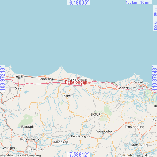
Pekalongan GPS coordinates[2]
6° 53' 18.96" South, 109° 40' 31.08" East
| Map corner | latitude | longitude |
|---|---|---|
| Upper-left | -6.19005°, | 108.97218° |
| Center: | -6.8886°, | 109.6753° |
| Lower-right: | -7.58612°, | 110.37843° |
| Map W x H: | 155.2×155.2 km | = 96.4×96.4mi |
| max Lat: | 5.88969° ⇑26.4% North |
| Pekalongan: | -6.8886° |
| min Lat: | ⇓73.6% South -10.934° |
| min Long | Pekalongan | max Long |
| 95.1345° | 109.6753° | 140.9419° |
| W 34.2%⇐ | ⇒65.8% E |
Elevation
Elevation of Pekalongan is 10 m = 33 ft, and this is 219.7 m = 721 ft below average elevation for this country.
| Max E: |
3185 m = 10449 ft | 90.6% |
| Avg. | 229.7 m = 754 ft | |
| Pekalongan | 10 m = 33 ft | |
Min E: |
-1 m = -3 ft | 9.4% |
See also: Pekalongan elevation on elevation.city.
Geographical zone
Pekalongan is located in South Torrid zone (between Equator and Tropic of Capricorn). Distance of Equator is 765.9 km =475.9 mi to North.| Distance of | km | miles | from Pekalongan |
|---|---|---|---|
| Equator | 765.9 | 475.9 | to North |
| Tropic Capricorn | 1840 | 1143.3 | to South |
| Antarctic Circle | 6635.2 | 4122.9 | to South |
| South Pole | 9241.1 | 5742.2 | to South |


Nearby cities:
15 places around Pekalongan: (largest is in red/bold)
• Banjarnegara
56.5 km =35.1 mi,  177°
177°
• Batang
6.4 km =4 mi,  109°
109°
• Buaran
22.7 km =14.1 mi,  217°
217°
• Comal
15.6 km =9.7 mi,  263°
263°
• Kajen
19.3 km =12 mi,  214°
214°
• Kedungwuni
9.6 km =6 mi,  198°
198°
• Kendal
58.3 km =36.2 mi,  93°
93°
• Pemalang
32.3 km =20.1 mi,  269°
269°
• Randudongkal
45.2 km =28.1 mi,  238°
238°
• Tarub
56.4 km =35 mi, 264°
• Tegal
59.1 km =36.7 mi, 272°
• Weleri
44.2 km =27.5 mi,  102°
102°
• Wiradesa
6.2 km =3.9 mi, 266°
• Wonopringgo
12.4 km =7.7 mi, 211°
• Wonosobo
58 km =36 mi,  154°
154°
Sources, notices
• [Note1] Compared only with cities in Indonesia existing in our database
• [Src1] Map data: © OpenStreetMap contributors (CC-BY-SA)
• [Src2] Other city data from geonames.org with taken over terms of usage.
• [Src3] Geographical zone / Annual Mean Temperature by Robert A. Rohde @ Wikipedia
