Nganjuk geodata
Nganjuk (East Java) is a seat of a second-order administrative division; located in Indonesia in Asia/Jakarta (GMT+7) time zone. With population of 69,011 people, there are 181 cities with bigger population in this country. Compared to other cities in Indonesia, 58.2% of cities are located further ↑North; 51.3% of cities are located further →East and 60.1% of cities have higher elevation than Nganjuk. Note1


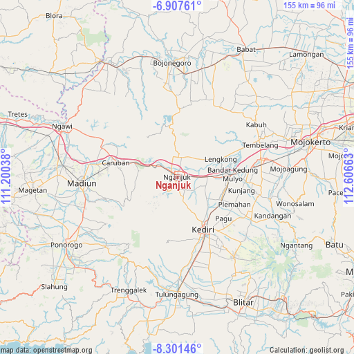
Nganjuk GPS coordinates[2]
7° 36' 18.36" South, 111° 54' 12.6" East
| Map corner | latitude | longitude |
|---|---|---|
| Upper-left | -6.90761°, | 111.20038° |
| Center: | -7.6051°, | 111.9035° |
| Lower-right: | -8.30146°, | 112.60663° |
| Map W x H: | 155×155 km | = 96.3×96.3mi |
| max Lat: | 5.88969° ⇑58.2% North |
| Nganjuk: | -7.6051° |
| min Lat: | ⇓41.8% South -10.934° |
| min Long | Nganjuk | max Long |
| 95.1345° | 111.9035° | 140.9419° |
| W 48.7%⇐ | ⇒51.3% E |
Elevation
Elevation of Nganjuk is 59 m = 194 ft, and this is 170.7 m = 560 ft below average elevation for this country.
| Max E: |
3185 m = 10449 ft | 60.1% |
| Avg. | 229.7 m = 754 ft | |
| Nganjuk | 59 m = 194 ft | |
Min E: |
-1 m = -3 ft | 39.9% |
See also: Nganjuk elevation on elevation.city.
Geographical zone
Nganjuk is located in South Torrid zone (between Equator and Tropic of Capricorn). Distance of Equator is 845.6 km =525.4 mi to North.| Distance of | km | miles | from Nganjuk |
|---|---|---|---|
| Equator | 845.6 | 525.4 | to North |
| Tropic Capricorn | 1760.3 | 1093.8 | to South |
| Antarctic Circle | 6555.6 | 4073.5 | to South |
| South Pole | 9161.5 | 5692.7 | to South |


Nearby cities:
15 places around Nganjuk: (largest is in red/bold)
• Caruban
28 km =17.4 mi,  283°
283°
• Diwek
36.2 km =22.5 mi,  85°
85°
• Gampengrejo
21.9 km =13.6 mi,  145°
145°
• Jombang
36.9 km =22.9 mi,  79°
79°
• Karangrejo
44.2 km =27.5 mi,  179°
179°
• Kediri
26.6 km =16.5 mi, 152°
• Kertosono
21.8 km =13.5 mi, 83°
• Madiun
41.9 km =26 mi,  266°
266°
• Ngasem
27 km =16.8 mi, 145°
• Ngoro
40 km =24.9 mi,  102°
102°
• Pabyongan
44.4 km =27.6 mi,  193°
193°
• Pakel
44.1 km =27.4 mi, 179°
• Pare
37.2 km =23.1 mi,  119°
119°
• Pulerejo
44.4 km =27.6 mi,  174°
174°
• Tiang
44.1 km =27.4 mi, 182°
Sources, notices
• [Note1] Compared only with cities in Indonesia existing in our database
• [Src1] Map data: © OpenStreetMap contributors (CC-BY-SA)
• [Src2] Other city data from geonames.org with taken over terms of usage.
• [Src3] Geographical zone / Annual Mean Temperature by Robert A. Rohde @ Wikipedia
