Elat geodata
Elat (Maluku) is a seat of a third-order administrative division; located in Indonesia in Asia/Jayapura (GMT+9) time zone. In our database, there are 407 cities with bigger population. Compared to other cities in Indonesia, 88.1% of cities are located further ↓South; 99% of cities are located further ←West and 53.4% of cities have higher elevation than Elat. Note1


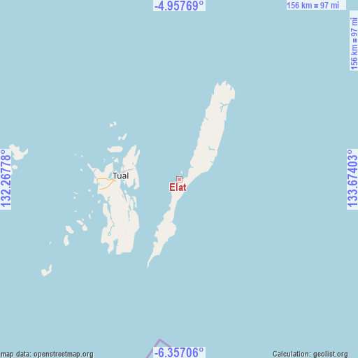
Elat GPS coordinates[2]
5° 39' 28.08" South, 132° 58' 15.24" East
| Map corner | latitude | longitude |
|---|---|---|
| Upper-left | -4.95769°, | 132.26778° |
| Center: | -5.6578°, | 132.9709° |
| Lower-right: | -6.35706°, | 133.67403° |
| Map W x H: | 155.6×155.6 km | = 96.7×96.7mi |
| max Lat: | 5.88969° ⇑11.9% North |
| Elat: | -5.6578° |
| min Lat: | ⇓88.1% South -10.934° |
| min Long | Elat | max Long |
| 95.1345° | 132.9709° | 140.9419° |
| W 99%⇐ | ⇒1% E |
Elevation
Elevation of Elat is 91 m = 299 ft, and this is 138.7 m = 455 ft below average elevation for this country.
| Max E: |
3185 m = 10449 ft | 53.4% |
| Avg. | 229.7 m = 754 ft | |
| Elat | 91 m = 299 ft | |
Min E: |
-1 m = -3 ft | 46.6% |
See also: Indonesia elevation on elevation.city.
Geographical zone
Elat is located in South Torrid zone (between Equator and Tropic of Capricorn). Distance of Equator is 629.1 km =390.9 mi to North.| Distance of | km | miles | from Elat |
|---|---|---|---|
| Equator | 629.1 | 390.9 | to North |
| Tropic Capricorn | 1976.8 | 1228.3 | to South |
| Antarctic Circle | 6772.1 | 4208 | to South |
| South Pole | 9378 | 5827.2 | to South |


Nearby cities:
15 places around Elat: (largest is in red/bold)
• Bofuer
307.1 km =190.8 mi,  16°
16°
• Dobo
140.2 km =87.1 mi,  94°
94°
• Dulanpokpok
313.4 km =194.7 mi,  345°
345°
• Fakfak
312.9 km =194.4 mi, 346°
• Geser
301.2 km =187.2 mi,  311°
311°
• Kaimana
238.6 km =148.3 mi, 21°
• Kiruru
292.5 km =181.8 mi,  49°
49°
• Kokas Kota
334 km =207.5 mi, 349°
• Kramongmongga
328.8 km =204.3 mi, 348°
• Kwantisore
341.8 km =212.4 mi,  38°
38°
• Langgur
25.8 km =16 mi,  267°
267°
• Onimsari
310.3 km =192.8 mi,  0°
0°
• Patipi Pasir
340.6 km =211.6 mi,  344°
344°
• Raduria
310.4 km =192.9 mi, 346°
• Tual
24.4 km =15.2 mi,  277°
277°
Sources, notices
• [Note1] Compared only with cities in Indonesia existing in our database
• [Src1] Map data: © OpenStreetMap contributors (CC-BY-SA)
• [Src2] Other city data from geonames.org with taken over terms of usage.
• [Src3] Geographical zone / Annual Mean Temperature by Robert A. Rohde @ Wikipedia
