Ampana geodata
Ampana (Central Sulawesi) is a seat of a second-order administrative division; located in Indonesia in Asia/Makassar (GMT+8) time zone. In our database, there are 407 cities with bigger population. Compared to other cities in Indonesia, 94.1% of cities are located further ↓South; 86.8% of cities are located further ←West and 62.8% of cities have higher elevation than Ampana. Note1


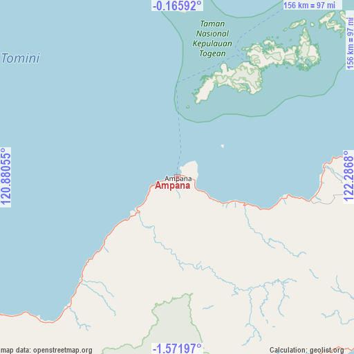
Ampana GPS coordinates[2]
0° 52' 8.436" South, 121° 35' 1.212" East
| Map corner | latitude | longitude |
|---|---|---|
| Upper-left | -0.16592°, | 120.88055° |
| Center: | -0.86901°, | 121.58367° |
| Lower-right: | -1.57197°, | 122.2868° |
| Map W x H: | 156.3×156.3 km | = 97.1×97.1mi |
| max Lat: | 5.88969° ⇑5.9% North |
| Ampana: | -0.86901° |
| min Lat: | ⇓94.1% South -10.934° |
| min Long | Ampana | max Long |
| 95.1345° | 121.58367° | 140.9419° |
| W 86.8%⇐ | ⇒13.2% E |
Elevation
Elevation of Ampana is 49 m = 161 ft, and this is 180.7 m = 593 ft below average elevation for this country.
| Max E: |
3185 m = 10449 ft | 62.8% |
| Avg. | 229.7 m = 754 ft | |
| Ampana | 49 m = 161 ft | |
Min E: |
-1 m = -3 ft | 37.2% |
See also: Indonesia elevation on elevation.city.
Geographical zone
Ampana is located in South Torrid zone (between Equator and Tropic of Capricorn). Distance of Equator is 96.6 km =60 mi to North.| Distance of | km | miles | from Ampana |
|---|---|---|---|
| Equator | 96.6 | 60 | to North |
| Tropic Capricorn | 2509.3 | 1559.2 | to South |
| Antarctic Circle | 7304.5 | 4538.8 | to South |
| South Pole | 9910.4 | 6158 | to South |


Nearby cities:
15 places around Ampana: (largest is in red/bold)
• Bungku
191.5 km =119 mi,  166°
166°
• Kasiguncu
120.1 km =74.6 mi,  239°
239°
• Kolonodale
126.8 km =78.8 mi,  192°
192°
• Lemito
156.9 km =97.5 mi,  359°
359°
• Luwuk
134.2 km =83.4 mi,  93°
93°
• Marisa
153.5 km =95.4 mi,  14°
14°
• Palu
190.5 km =118.4 mi,  268°
268°
• Parigi
156.5 km =97.2 mi, 272°
• Pendolo
167.2 km =103.9 mi,  216°
216°
• Poso
109.4 km =68 mi, 237°
• Salakan
196 km =121.8 mi,  104°
104°
• Sigi Biromaru
185.4 km =115.2 mi, 267°
• Tagolu
110.2 km =68.5 mi,  234°
234°
• Tentena
143.3 km =89 mi, 226°
• Tilamuta
176.9 km =109.9 mi,  28°
28°
Sources, notices
• [Note1] Compared only with cities in Indonesia existing in our database
• [Src1] Map data: © OpenStreetMap contributors (CC-BY-SA)
• [Src2] Other city data from geonames.org with taken over terms of usage.
• [Src3] Geographical zone / Annual Mean Temperature by Robert A. Rohde @ Wikipedia
