Luwuk geodata
Luwuk (Central Sulawesi) is a seat of a second-order administrative division; located in Indonesia in Asia/Makassar (GMT+8) time zone. With population of 47,778 people, there are 242 cities with bigger population in this country. Compared to other cities in Indonesia, 93.9% of cities are located further ↓South; 89.3% of cities are located further ←West and 81.9% of cities have higher elevation than Luwuk. Note1


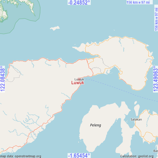
Luwuk GPS coordinates[2]
0° 57' 5.76" South, 122° 47' 15" East
| Map corner | latitude | longitude |
|---|---|---|
| Upper-left | -0.24852°, | 122.08438° |
| Center: | -0.9516°, | 122.7875° |
| Lower-right: | -1.65454°, | 123.49063° |
| Map W x H: | 156.3×156.3 km | = 97.1×97.1mi |
| max Lat: | 5.88969° ⇑6.1% North |
| Luwuk: | -0.9516° |
| min Lat: | ⇓93.9% South -10.934° |
| min Long | Luwuk | max Long |
| 95.1345° | 122.7875° | 140.9419° |
| W 89.3%⇐ | ⇒10.7% E |
Elevation
Elevation of Luwuk is 17 m = 56 ft, and this is 212.7 m = 698 ft below average elevation for this country.
| Max E: |
3185 m = 10449 ft | 81.9% |
| Avg. | 229.7 m = 754 ft | |
| Luwuk | 17 m = 56 ft | |
Min E: |
-1 m = -3 ft | 18.1% |
See also: Luwuk elevation on elevation.city.
Geographical zone
Luwuk is located in South Torrid zone (between Equator and Tropic of Capricorn). Distance of Equator is 105.8 km =65.7 mi to North.| Distance of | km | miles | from Luwuk |
|---|---|---|---|
| Equator | 105.8 | 65.7 | to North |
| Tropic Capricorn | 2500.1 | 1553.5 | to South |
| Antarctic Circle | 7295.4 | 4533.1 | to South |
| South Pole | 9901.3 | 6152.4 | to South |


Nearby cities:
15 places around Luwuk: (largest is in red/bold)
• Ampana
134.2 km =83.4 mi,  273°
273°
• Banggai
106.2 km =66 mi,  131°
131°
• Bilungala
155.6 km =96.7 mi,  17°
17°
• Gorontalo
168.4 km =104.6 mi,  10°
10°
• Isimu
177.7 km =110.4 mi,  2°
2°
• Kolonodale
197.9 km =123 mi,  234°
234°
• Kwandang
199.1 km =123.7 mi, 4°
• Limboto
176.8 km =109.9 mi, 6°
• Marisa
183.7 km =114.1 mi,  329°
329°
• Molobulahe
177.7 km =110.4 mi,  352°
352°
• Payunga
169.4 km =105.3 mi, 6°
• Salakan
68.6 km =42.6 mi, 125°
• Sidomulyo
179.1 km =111.3 mi, 353°
• Suwawa
169.8 km =105.5 mi, 13°
• Tilamuta
171.6 km =106.6 mi,  343°
343°
Sources, notices
• [Note1] Compared only with cities in Indonesia existing in our database
• [Src1] Map data: © OpenStreetMap contributors (CC-BY-SA)
• [Src2] Other city data from geonames.org with taken over terms of usage.
• [Src3] Geographical zone / Annual Mean Temperature by Robert A. Rohde @ Wikipedia
