Palu geodata
Palu (Central Sulawesi) is a seat of a first-order administrative division; located in Indonesia in Asia/Makassar (GMT+8) time zone. With population of 282,431 people, there are 34 cities with bigger population in this country. Compared to other cities in Indonesia, 94% of cities are located further ↓South; 82.4% of cities are located further ←West and 92.1% of cities have higher elevation than Palu. Note1


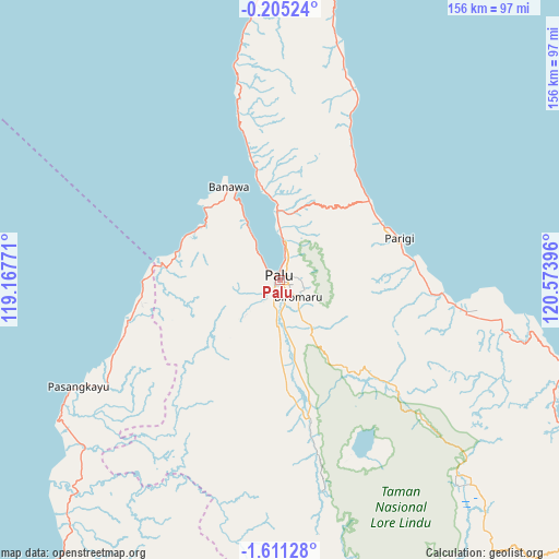
Palu GPS coordinates[2]
0° 54' 29.988" South, 119° 52' 14.988" East
| Map corner | latitude | longitude |
|---|---|---|
| Upper-left | -0.20524°, | 119.16771° |
| Center: | -0.90833°, | 119.87083° |
| Lower-right: | -1.61128°, | 120.57396° |
| Map W x H: | 156.3×156.3 km | = 97.1×97.1mi |
| max Lat: | 5.88969° ⇑6% North |
| Palu: | -0.90833° |
| min Lat: | ⇓94% South -10.934° |
| min Long | Palu | max Long |
| 95.1345° | 119.87083° | 140.9419° |
| W 82.4%⇐ | ⇒17.6% E |
Elevation
Elevation of Palu is 9 m = 30 ft, and this is 220.7 m = 724 ft below average elevation for this country.
| Max E: |
3185 m = 10449 ft | 92.1% |
| Avg. | 229.7 m = 754 ft | |
| Palu | 9 m = 30 ft | |
Min E: |
-1 m = -3 ft | 7.9% |
See also: Palu elevation on elevation.city.
Geographical zone
Palu is located in South Torrid zone (between Equator and Tropic of Capricorn). Distance of Equator is 101 km =62.8 mi to North.| Distance of | km | miles | from Palu |
|---|---|---|---|
| Equator | 101 | 62.8 | to North |
| Tropic Capricorn | 2504.9 | 1556.5 | to South |
| Antarctic Circle | 7300.2 | 4536.1 | to South |
| South Pole | 9906.1 | 6155.4 | to South |


Nearby cities:
15 places around Palu: (largest is in red/bold)
• Ampana
190.5 km =118.4 mi,  88°
88°
• Babana
150 km =93.2 mi,  209°
209°
• Bonebone
201.5 km =125.2 mi,  159°
159°
• Donggala
30 km =18.6 mi,  331°
331°
• Kalumpang
179.7 km =111.7 mi,  193°
193°
• Kasiguncu
104.2 km =64.7 mi,  123°
123°
• Masamba
189.9 km =118 mi, 164°
• Parigi
35.5 km =22.1 mi,  73°
73°
• Pendolo
158.1 km =98.2 mi,  145°
145°
• Poso
112 km =69.6 mi, 118°
• Sigi Biromaru
7 km =4.3 mi,  131°
131°
• Sukamaju
200.4 km =124.5 mi, 160°
• Tagolu
116.4 km =72.3 mi, 120°
• Tentena
127.9 km =79.5 mi,  137°
137°
• Tobadak
143.6 km =89.2 mi,  203°
203°
Sources, notices
• [Note1] Compared only with cities in Indonesia existing in our database
• [Src1] Map data: © OpenStreetMap contributors (CC-BY-SA)
• [Src2] Other city data from geonames.org with taken over terms of usage.
• [Src3] Geographical zone / Annual Mean Temperature by Robert A. Rohde @ Wikipedia
