Salakan geodata
Salakan (Central Sulawesi) is a seat of a second-order administrative division; located in Indonesia in Asia/Makassar (GMT+8) time zone. In our database, there are 407 cities with bigger population. Compared to other cities in Indonesia, 93.6% of cities are located further ↓South; 91.7% of cities are located further ←West and 100% of cities have higher elevation than Salakan. Note1


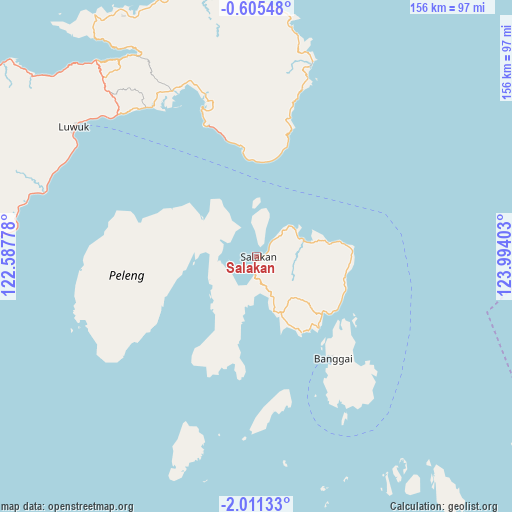
Salakan GPS coordinates[2]
1° 18' 30.6" South, 123° 17' 27.24" East
| Map corner | latitude | longitude |
|---|---|---|
| Upper-left | -0.60548°, | 122.58778° |
| Center: | -1.3085°, | 123.2909° |
| Lower-right: | -2.01133°, | 123.99403° |
| Map W x H: | 156.3×156.3 km | = 97.1×97.1mi |
| max Lat: | 5.88969° ⇑6.4% North |
| Salakan: | -1.3085° |
| min Lat: | ⇓93.6% South -10.934° |
| min Long | Salakan | max Long |
| 95.1345° | 123.2909° | 140.9419° |
| W 91.7%⇐ | ⇒8.3% E |
Elevation
Elevation of Salakan is 0 m = 0 ft, and this is 229.7 m = 754 ft below average elevation for this country.
| Max E: |
3185 m = 10449 ft | 100% |
| Avg. | 229.7 m = 754 ft | |
| Salakan | 0 m = 0 ft | |
Min E: |
-1 m = -3 ft | 0% |
See also: Indonesia elevation on elevation.city.
Geographical zone
Salakan is located in South Torrid zone (between Equator and Tropic of Capricorn). Distance of Equator is 145.5 km =90.4 mi to North.| Distance of | km | miles | from Salakan |
|---|---|---|---|
| Equator | 145.5 | 90.4 | to North |
| Tropic Capricorn | 2460.4 | 1528.8 | to South |
| Antarctic Circle | 7255.7 | 4508.5 | to South |
| South Pole | 9861.6 | 6127.7 | to South |


Nearby cities:
15 places around Salakan: (largest is in red/bold)
• Ampana
196 km =121.8 mi,  284°
284°
• Banggai
38.8 km =24.1 mi,  143°
143°
• Bilungala
188.1 km =116.9 mi,  357°
357°
• Bobong
140.7 km =87.4 mi,  120°
120°
• Bungku
201.1 km =125 mi,  226°
226°
• Gorontalo
206.8 km =128.5 mi,  352°
352°
• Isimu
222.4 km =138.2 mi, 347°
• Kolonodale
229.8 km =142.8 mi,  250°
250°
• Limboto
218 km =135.5 mi, 350°
• Luwuk
68.6 km =42.6 mi,  305°
305°
• Molibagu
203.5 km =126.4 mi,  22°
22°
• Molobulahe
230 km =142.9 mi,  339°
339°
• Payunga
211.5 km =131.4 mi, 349°
• Suwawa
205.3 km =127.6 mi, 355°
• Tilamuta
229.6 km =142.7 mi,  332°
332°
Sources, notices
• [Note1] Compared only with cities in Indonesia existing in our database
• [Src1] Map data: © OpenStreetMap contributors (CC-BY-SA)
• [Src2] Other city data from geonames.org with taken over terms of usage.
• [Src3] Geographical zone / Annual Mean Temperature by Robert A. Rohde @ Wikipedia
