Youghal geodata
Youghal (Munster) is a populated place; located in Ireland in Europe/Dublin (GMT+1) time zone. With population of 6,868 people, there are 98 cities with bigger population in this country. Compared to other cities in Ireland, 93% of cities are located further ↑North; 60% of cities are located further →East and 59.8% of cities have lower elevation than Youghal. Note1


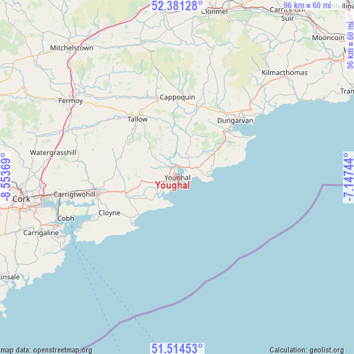
Youghal GPS coordinates[2]
51° 57' 0" North, 7° 51' 2.016" West
| Map corner | latitude | longitude |
|---|---|---|
| Upper-left | 52.38128°, | -8.55369° |
| Center: | 51.95°, | -7.85056° |
| Lower-right: | 51.51453°, | -7.14744° |
| Map W x H: | 96.4×96.4 km | = 59.9×59.9mi |
| max Lat: | 55.25° ⇑93% North |
| Youghal: | 51.95° |
| min Lat: | ⇓7% South 51.52487° |
| min Long | Youghal | max Long |
| -10.26889° | -7.85056° | -6.04944° |
| W 40%⇐ | ⇒60% E |
Elevation
Elevation of Youghal is 60 m = 197 ft, and this is 5.5 m = 18 ft above average elevation for this country.
| Max E: |
262 m = 860 ft | 40.2% |
| Youghal | 60 m 197 ft | |
| Avg. | 54.5 m = 179 ft | |
Min E: |
0 m = 0 ft | 59.8% |
See also: Ireland elevation on elevation.city.
Geographical zone
Youghal is located in North temperate zone (between Tropic of Cancer and the Arctic Circle). Distance of this North polar circle is 1624.9 km =1009.7 mi to North.| Distance of | km | miles | from Youghal |
|---|---|---|---|
| North Pole | 4230.8 | 2628.9 | to North |
| Arctic Circle | 1624.9 | 1009.7 | to North |
| Tropic Cancer | 3170.4 | 1970 | to South |
| Equator | 5776.3 | 3589.2 | to South |


Nearby cities:
15 places around Youghal: (largest is in red/bold)
• Aghada
27.7 km =17.2 mi,  243°
243°
• Cappoquin
21.9 km =13.6 mi,  359°
359°
• Carrigtwohill
28.7 km =17.8 mi,  260°
260°
• Castlemartyr
14.6 km =9.1 mi,  252°
252°
• Cloyne
21.1 km =13.1 mi, 242°
• Cobh
32.4 km =20.1 mi, 250°
• Crosshaven
35.2 km =21.9 mi, 241°
• Dungarvan
21.8 km =13.5 mi,  45°
45°
• Killeagh
10.1 km =6.3 mi,  265°
265°
• Midleton
22.9 km =14.2 mi, 260°
• Passage West
34.9 km =21.7 mi, 255°
• Rathcormac
32.7 km =20.3 mi,  295°
295°
• Tallow
19.2 km =11.9 mi,  325°
325°
• Watergrasshill
34.5 km =21.4 mi,  281°
281°
• Whitegate
29.2 km =18.1 mi, 242°
Sources, notices
• [Note1] Compared only with cities in Ireland existing in our database
• [Src1] Map data: © OpenStreetMap contributors (CC-BY-SA)
• [Src2] Other city data from geonames.org with taken over terms of usage.
• [Src3] Geographical zone / Annual Mean Temperature by Robert A. Rohde @ Wikipedia
