Cappoquin geodata
Cappoquin (Munster) is a populated place; located in Ireland in Europe/Dublin (GMT+1) time zone. With population of 759 people, there are 415 cities with bigger population in this country. Compared to other cities in Ireland, 89.9% of cities are located further ↑North; 60.2% of cities are located further →East and 99.1% of cities have higher elevation than Cappoquin. Note1


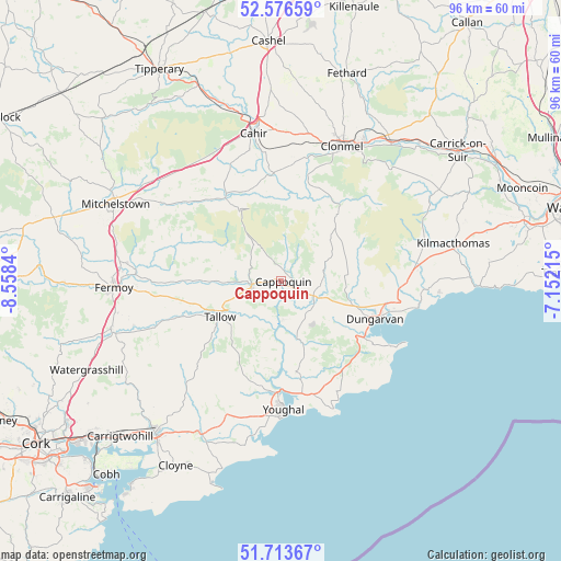
Cappoquin GPS coordinates[2]
52° 8' 49.992" North, 7° 51' 19.008" West
| Map corner | latitude | longitude |
|---|---|---|
| Upper-left | 52.57659°, | -8.5584° |
| Center: | 52.14722°, | -7.85528° |
| Lower-right: | 51.71367°, | -7.15215° |
| Map W x H: | 95.9×95.9 km | = 59.6×59.6mi |
| max Lat: | 55.25° ⇑89.9% North |
| Cappoquin: | 52.14722° |
| min Lat: | ⇓10.1% South 51.52487° |
| min Long | Cappoquin | max Long |
| -10.26889° | -7.85528° | -6.04944° |
| W 39.8%⇐ | ⇒60.2% E |
Elevation
Elevation of Cappoquin is 3 m = 10 ft, and this is 51.5 m = 169 ft below average elevation for this country.
| Max E: |
262 m = 860 ft | 99.1% |
| Avg. | 54.5 m = 179 ft | |
| Cappoquin | 3 m = 10 ft | |
Min E: |
0 m = 0 ft | 0.9% |
See also: Ireland elevation on elevation.city.
Geographical zone
Cappoquin is located in North temperate zone (between Tropic of Cancer and the Arctic Circle). Distance of this North polar circle is 1602.9 km =996 mi to North.| Distance of | km | miles | from Cappoquin |
|---|---|---|---|
| North Pole | 4208.8 | 2615.2 | to North |
| Arctic Circle | 1602.9 | 996 | to North |
| Tropic Cancer | 3192.3 | 1983.6 | to South |
| Equator | 5798.2 | 3602.8 | to South |


Nearby cities:
15 places around Cappoquin: (largest is in red/bold)
• Ardfinnan
18.3 km =11.4 mi,  355°
355°
• Ballyclerahan
30.1 km =18.7 mi,  12°
12°
• Cahir
25.9 km =16.1 mi,  349°
349°
• Castlemartyr
29.6 km =18.4 mi,  207°
207°
• Cluain Meala
25.3 km =15.7 mi,  24°
24°
• Dungarvan
17 km =10.6 mi,  112°
112°
• Fermoy
28.7 km =17.8 mi,  267°
267°
• Killeagh
24.8 km =15.4 mi,  203°
203°
• Kilmacthomas
30 km =18.6 mi,  77°
77°
• Kilsheelan
30.3 km =18.8 mi,  38°
38°
• Kilworth
26.7 km =16.6 mi,  276°
276°
• Mitchelstown
31.1 km =19.3 mi,  295°
295°
• Rathcormac
30.2 km =18.8 mi,  254°
254°
• Tallow
12.1 km =7.5 mi,  239°
239°
• Youghal
21.9 km =13.6 mi,  179°
179°
Sources, notices
• [Note1] Compared only with cities in Ireland existing in our database
• [Src1] Map data: © OpenStreetMap contributors (CC-BY-SA)
• [Src2] Other city data from geonames.org with taken over terms of usage.
• [Src3] Geographical zone / Annual Mean Temperature by Robert A. Rohde @ Wikipedia
