Rathcormac geodata
Rathcormac (Munster) is a populated place; located in Ireland in Europe/Dublin (GMT+1) time zone. With population of 1,534 people, there are 273 cities with bigger population in this country. Compared to other cities in Ireland, 91.7% of cities are located further ↑North; 68.7% of cities are located further →East and 55.4% of cities have lower elevation than Rathcormac. Note1


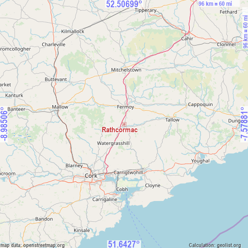
Rathcormac GPS coordinates[2]
52° 4' 36.984" North, 8° 16' 54.984" West
| Map corner | latitude | longitude |
|---|---|---|
| Upper-left | 52.50699°, | -8.98506° |
| Center: | 52.07694°, | -8.28194° |
| Lower-right: | 51.6427°, | -7.57881° |
| Map W x H: | 96.1×96.1 km | = 59.7×59.7mi |
| max Lat: | 55.25° ⇑91.7% North |
| Rathcormac: | 52.07694° |
| min Lat: | ⇓8.3% South 51.52487° |
| min Long | Rathcormac | max Long |
| -10.26889° | -8.28194° | -6.04944° |
| W 31.3%⇐ | ⇒68.7% E |
Elevation
Elevation of Rathcormac is 56 m = 184 ft, and this is 1.5 m = 5 ft above average elevation for this country.
| Max E: |
262 m = 860 ft | 44.6% |
| Rathcormac | 56 m 184 ft | |
| Avg. | 54.5 m = 179 ft | |
Min E: |
0 m = 0 ft | 55.4% |
See also: Ireland elevation on elevation.city.
Geographical zone
Rathcormac is located in North temperate zone (between Tropic of Cancer and the Arctic Circle). Distance of this North polar circle is 1610.8 km =1000.9 mi to North.| Distance of | km | miles | from Rathcormac |
|---|---|---|---|
| North Pole | 4216.6 | 2620.1 | to North |
| Arctic Circle | 1610.8 | 1000.9 | to North |
| Tropic Cancer | 3184.5 | 1978.8 | to South |
| Equator | 5790.4 | 3598 | to South |


Nearby cities:
15 places around Rathcormac: (largest is in red/bold)
• Carrigtwohill
18.8 km =11.7 mi,  176°
176°
• Castlemartyr
24.2 km =15 mi,  139°
139°
• Cork
23.7 km =14.7 mi,  212°
212°
• Fermoy
6.6 km =4.1 mi,  3°
3°
• Glanworth
13.2 km =8.2 mi,  337°
337°
• Grenagh
23.4 km =14.5 mi,  252°
252°
• Killeagh
24.5 km =15.2 mi,  127°
127°
• Kilworth
11.4 km =7.1 mi,  13°
13°
• Mallow
24.8 km =15.4 mi,  284°
284°
• Midleton
19.3 km =12 mi,  158°
158°
• Mitchelstown
21 km =13 mi, 2°
• Passage West
23 km =14.3 mi,  190°
190°
• Tallow
18.8 km =11.7 mi,  84°
84°
• Watergrasshill
8.4 km =5.2 mi, 210°
• Whitechurch
19.1 km =11.9 mi,  236°
236°
Sources, notices
• [Note1] Compared only with cities in Ireland existing in our database
• [Src1] Map data: © OpenStreetMap contributors (CC-BY-SA)
• [Src2] Other city data from geonames.org with taken over terms of usage.
• [Src3] Geographical zone / Annual Mean Temperature by Robert A. Rohde @ Wikipedia
