Dunmanway geodata
Dunmanway (Munster) is a populated place; located in Ireland in Europe/Dublin (GMT+1) time zone. With population of 1,585 people, there are 260 cities with bigger population in this country. Compared to other cities in Ireland, 98.3% of cities are located further ↑North; 91.5% of cities are located further →East and 66% of cities have lower elevation than Dunmanway. Note1


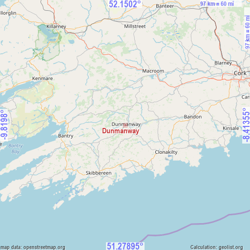
Dunmanway GPS coordinates[2]
51° 43' 0.012" North, 9° 7' 0.012" West
| Map corner | latitude | longitude |
|---|---|---|
| Upper-left | 52.1502°, | -9.8198° |
| Center: | 51.71667°, | -9.11667° |
| Lower-right: | 51.27895°, | -8.41355° |
| Map W x H: | 96.9×96.9 km | = 60.2×60.2mi |
| max Lat: | 55.25° ⇑98.3% North |
| Dunmanway: | 51.71667° |
| min Lat: | ⇓1.7% South 51.52487° |
| min Long | Dunmanway | max Long |
| -10.26889° | -9.11667° | -6.04944° |
| W 8.5%⇐ | ⇒91.5% E |
Elevation
Elevation of Dunmanway is 65 m = 213 ft, and this is 10.5 m = 34 ft above average elevation for this country.
| Max E: |
262 m = 860 ft | 34% |
| Dunmanway | 65 m 213 ft | |
| Avg. | 54.5 m = 179 ft | |
Min E: |
0 m = 0 ft | 66% |
See also: Ireland elevation on elevation.city.
Geographical zone
Dunmanway is located in North temperate zone (between Tropic of Cancer and the Arctic Circle). Distance of this North polar circle is 1650.8 km =1025.8 mi to North.| Distance of | km | miles | from Dunmanway |
|---|---|---|---|
| North Pole | 4256.7 | 2645 | to North |
| Arctic Circle | 1650.8 | 1025.8 | to North |
| Tropic Cancer | 3144.4 | 1953.8 | to South |
| Equator | 5750.4 | 3573.1 | to South |


Nearby cities:
15 places around Dunmanway: (largest is in red/bold)
• Bandon
26 km =16.2 mi,  82°
82°
• Bantry
23.3 km =14.5 mi,  260°
260°
• Clonakilty
19.9 km =12.4 mi,  121°
121°
• Courtmacsherry
29.9 km =18.6 mi,  108°
108°
• Derry
15.2 km =9.4 mi,  162°
162°
• Enniskeane
13 km =8.1 mi, 79°
• Innishannon
32.1 km =19.9 mi, 80°
• Kenmare
37.1 km =23.1 mi,  300°
300°
• Killumney
36.6 km =22.7 mi,  61°
61°
• Macroom
23.4 km =14.5 mi,  25°
25°
• Millstreet
38.3 km =23.8 mi,  5°
5°
• Rathard
29.9 km =18.6 mi, 60°
• Ross Carbery
16.5 km =10.3 mi, 159°
• Schull
36.6 km =22.7 mi,  234°
234°
• Skibbereen
21.2 km =13.2 mi,  209°
209°
Sources, notices
• [Note1] Compared only with cities in Ireland existing in our database
• [Src1] Map data: © OpenStreetMap contributors (CC-BY-SA)
• [Src2] Other city data from geonames.org with taken over terms of usage.
• [Src3] Geographical zone / Annual Mean Temperature by Robert A. Rohde @ Wikipedia
