Clonakilty geodata
Clonakilty (Munster) is a populated place; located in Ireland in Europe/Dublin (GMT+1) time zone. With population of 4,065 people, there are 154 cities with bigger population in this country. Compared to other cities in Ireland, 99.2% of cities are located further ↑North; 86% of cities are located further →East and 51.6% of cities have lower elevation than Clonakilty. Note1


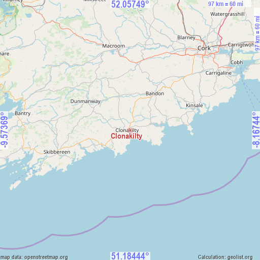
Clonakilty GPS coordinates[2]
51° 37' 23.016" North, 8° 52' 14.016" West
| Map corner | latitude | longitude |
|---|---|---|
| Upper-left | 52.05749°, | -9.57369° |
| Center: | 51.62306°, | -8.87056° |
| Lower-right: | 51.18444°, | -8.16744° |
| Map W x H: | 97.1×97.1 km | = 60.3×60.3mi |
| max Lat: | 55.25° ⇑99.2% North |
| Clonakilty: | 51.62306° |
| min Lat: | ⇓0.8% South 51.52487° |
| min Long | Clonakilty | max Long |
| -10.26889° | -8.87056° | -6.04944° |
| W 14%⇐ | ⇒86% E |
Elevation
Elevation of Clonakilty is 53 m = 174 ft, and this is 1.5 m = 5 ft below average elevation for this country.
| Max E: |
262 m = 860 ft | 48.4% |
| Avg. | 54.5 m = 179 ft | |
| Clonakilty | 53 m = 174 ft | |
Min E: |
0 m = 0 ft | 51.6% |
See also: Ireland elevation on elevation.city.
Geographical zone
Clonakilty is located in North temperate zone (between Tropic of Cancer and the Arctic Circle). Distance of this North polar circle is 1661.2 km =1032.2 mi to North.| Distance of | km | miles | from Clonakilty |
|---|---|---|---|
| North Pole | 4267.1 | 2651.5 | to North |
| Arctic Circle | 1661.2 | 1032.2 | to North |
| Tropic Cancer | 3134 | 1947.4 | to South |
| Equator | 5739.9 | 3566.6 | to South |


Nearby cities:
15 places around Clonakilty: (largest is in red/bold)
• Ballygarvan
35.8 km =22.2 mi,  51°
51°
• Bandon
16.4 km =10.2 mi,  32°
32°
• Belgooly
29.2 km =18.1 mi,  63°
63°
• Courtmacsherry
11.5 km =7.1 mi,  84°
84°
• Derry
13.1 km =8.1 mi,  251°
251°
• Dunmanway
19.9 km =12.4 mi,  301°
301°
• Enniskeane
13.4 km =8.3 mi,  341°
341°
• Innishannon
21.6 km =13.4 mi,  42°
42°
• Killumney
31.7 km =19.7 mi, 28°
• Kinsale
25.3 km =15.7 mi,  68°
68°
• Macroom
32.3 km =20.1 mi,  347°
347°
• Rathard
26.6 km =16.5 mi,  20°
20°
• Riverstick
30.8 km =19.1 mi, 57°
• Ross Carbery
12.2 km =7.6 mi, 245°
• Skibbereen
28.5 km =17.7 mi, 253°
Sources, notices
• [Note1] Compared only with cities in Ireland existing in our database
• [Src1] Map data: © OpenStreetMap contributors (CC-BY-SA)
• [Src2] Other city data from geonames.org with taken over terms of usage.
• [Src3] Geographical zone / Annual Mean Temperature by Robert A. Rohde @ Wikipedia
