Bandon geodata
Bandon (Munster) is a populated place; located in Ireland in Europe/Dublin (GMT+1) time zone. With population of 5,492 people, there are 125 cities with bigger population in this country. Compared to other cities in Ireland, 97.7% of cities are located further ↑North; 82.9% of cities are located further →East and 67.4% of cities have higher elevation than Bandon. Note1


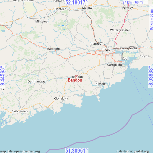
Bandon GPS coordinates[2]
51° 44' 48.984" North, 8° 44' 33" West
| Map corner | latitude | longitude |
|---|---|---|
| Upper-left | 52.18017°, | -9.44563° |
| Center: | 51.74694°, | -8.7425° |
| Lower-right: | 51.30951°, | -8.03938° |
| Map W x H: | 96.8×96.8 km | = 60.1×60.1mi |
| max Lat: | 55.25° ⇑97.7% North |
| Bandon: | 51.74694° |
| min Lat: | ⇓2.3% South 51.52487° |
| min Long | Bandon | max Long |
| -10.26889° | -8.7425° | -6.04944° |
| W 17.1%⇐ | ⇒82.9% E |
Elevation
Elevation of Bandon is 28 m = 92 ft, and this is 26.5 m = 87 ft below average elevation for this country.
| Max E: |
262 m = 860 ft | 67.4% |
| Avg. | 54.5 m = 179 ft | |
| Bandon | 28 m = 92 ft | |
Min E: |
0 m = 0 ft | 32.6% |
See also: Ireland elevation on elevation.city.
Geographical zone
Bandon is located in North temperate zone (between Tropic of Cancer and the Arctic Circle). Distance of this North polar circle is 1647.5 km =1023.7 mi to North.| Distance of | km | miles | from Bandon |
|---|---|---|---|
| North Pole | 4253.3 | 2642.9 | to North |
| Arctic Circle | 1647.5 | 1023.7 | to North |
| Tropic Cancer | 3147.8 | 1956 | to South |
| Equator | 5753.7 | 3575.2 | to South |


Nearby cities:
15 places around Bandon: (largest is in red/bold)
• Ballygarvan
21 km =13 mi,  66°
66°
• Belgooly
17.4 km =10.8 mi,  92°
92°
• Blarney
24 km =14.9 mi,  30°
30°
• Carrigaline
24.7 km =15.3 mi, 73°
• Clonakilty
16.4 km =10.2 mi,  212°
212°
• Cork
25.1 km =15.6 mi,  48°
48°
• Courtmacsherry
12.9 km =8 mi,  168°
168°
• Enniskeane
13.1 km =8.1 mi,  265°
265°
• Innishannon
6.2 km =3.9 mi, 70°
• Killumney
15.4 km =9.6 mi, 25°
• Kinsale
15.2 km =9.4 mi,  106°
106°
• Macroom
23.6 km =14.7 mi,  318°
318°
• Rathard
11.3 km =7 mi,  1°
1°
• Riverstick
17.3 km =10.7 mi,  80°
80°
• Tower
22 km =13.7 mi,  24°
24°
Sources, notices
• [Note1] Compared only with cities in Ireland existing in our database
• [Src1] Map data: © OpenStreetMap contributors (CC-BY-SA)
• [Src2] Other city data from geonames.org with taken over terms of usage.
• [Src3] Geographical zone / Annual Mean Temperature by Robert A. Rohde @ Wikipedia
