Courtmacsherry geodata
Courtmacsherry (Munster) is a populated place; located in Ireland in Europe/Dublin (GMT+1) time zone. With population of 520 people, there are 514 cities with bigger population in this country. Compared to other cities in Ireland, 99.1% of cities are located further ↑North; 81.4% of cities are located further →East and 78.4% of cities have higher elevation than Courtmacsherry. Note1


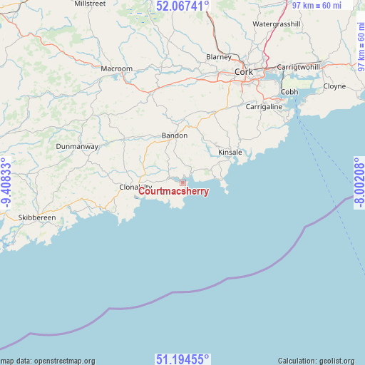
Courtmacsherry GPS coordinates[2]
51° 37' 59.088" North, 8° 42' 18.756" West
| Map corner | latitude | longitude |
|---|---|---|
| Upper-left | 52.06741°, | -9.40833° |
| Center: | 51.63308°, | -8.70521° |
| Lower-right: | 51.19455°, | -8.00208° |
| Map W x H: | 97.1×97.1 km | = 60.3×60.3mi |
| max Lat: | 55.25° ⇑99.1% North |
| Courtmacsherry: | 51.63308° |
| min Lat: | ⇓0.9% South 51.52487° |
| min Long | Courtmacsherry | max Long |
| -10.26889° | -8.70521° | -6.04944° |
| W 18.6%⇐ | ⇒81.4% E |
Elevation
Elevation of Courtmacsherry is 18 m = 59 ft, and this is 36.5 m = 120 ft below average elevation for this country.
| Max E: |
262 m = 860 ft | 78.4% |
| Avg. | 54.5 m = 179 ft | |
| Courtmacsherry | 18 m = 59 ft | |
Min E: |
0 m = 0 ft | 21.6% |
See also: Ireland elevation on elevation.city.
Geographical zone
Courtmacsherry is located in North temperate zone (between Tropic of Cancer and the Arctic Circle). Distance of this North polar circle is 1660.1 km =1031.5 mi to North.| Distance of | km | miles | from Courtmacsherry |
|---|---|---|---|
| North Pole | 4266 | 2650.8 | to North |
| Arctic Circle | 1660.1 | 1031.5 | to North |
| Tropic Cancer | 3135.1 | 1948.1 | to South |
| Equator | 5741.1 | 3567.4 | to South |


Nearby cities:
15 places around Courtmacsherry: (largest is in red/bold)
• Ballygarvan
26.9 km =16.7 mi,  38°
38°
• Bandon
12.9 km =8 mi,  348°
348°
• Belgooly
18.9 km =11.7 mi,  51°
51°
• Carrigaline
29 km =18 mi, 46°
• Clonakilty
11.5 km =7.1 mi,  264°
264°
• Derry
24.4 km =15.2 mi, 257°
• Dunmanway
29.9 km =18.6 mi,  288°
288°
• Enniskeane
19.5 km =12.1 mi,  306°
306°
• Fountainstown
32.5 km =20.2 mi,  58°
58°
• Innishannon
15.1 km =9.4 mi,  12°
12°
• Killumney
26.9 km =16.7 mi, 8°
• Kinsale
14.6 km =9.1 mi, 55°
• Rathard
24 km =14.9 mi, 354°
• Riverstick
21.3 km =13.2 mi, 43°
• Ross Carbery
23.4 km =14.5 mi,  254°
254°
Sources, notices
• [Note1] Compared only with cities in Ireland existing in our database
• [Src1] Map data: © OpenStreetMap contributors (CC-BY-SA)
• [Src2] Other city data from geonames.org with taken over terms of usage.
• [Src3] Geographical zone / Annual Mean Temperature by Robert A. Rohde @ Wikipedia
