Roscommon geodata
Roscommon (Connaught) is a seat of a second-order administrative division; located in Ireland in Europe/Dublin (GMT+1) time zone. With population of 5,693 people, there are 119 cities with bigger population in this country. Compared to other cities in Ireland, 76.5% of cities are located further ↓South; 65.8% of cities are located further →East and 50.3% of cities have lower elevation than Roscommon. Note1


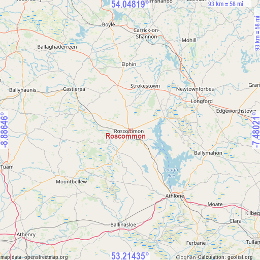
Roscommon GPS coordinates[2]
53° 37' 59.988" North, 8° 10' 59.988" West
| Map corner | latitude | longitude |
|---|---|---|
| Upper-left | 54.04819°, | -8.88646° |
| Center: | 53.63333°, | -8.18333° |
| Lower-right: | 53.21435°, | -7.48021° |
| Map W x H: | 92.7×92.7 km | = 57.6×57.6mi |
| max Lat: | 55.25° ⇑23.5% North |
| Roscommon: | 53.63333° |
| min Lat: | ⇓76.5% South 51.52487° |
| min Long | Roscommon | max Long |
| -10.26889° | -8.18333° | -6.04944° |
| W 34.2%⇐ | ⇒65.8% E |
Elevation
Elevation of Roscommon is 51 m = 167 ft, and this is 3.5 m = 11 ft below average elevation for this country.
| Max E: |
262 m = 860 ft | 49.7% |
| Avg. | 54.5 m = 179 ft | |
| Roscommon | 51 m = 167 ft | |
Min E: |
0 m = 0 ft | 50.3% |
See also: Ireland elevation on elevation.city.
Geographical zone
Roscommon is located in North temperate zone (between Tropic of Cancer and the Arctic Circle). Distance of this North polar circle is 1437.7 km =893.3 mi to North.| Distance of | km | miles | from Roscommon |
|---|---|---|---|
| North Pole | 4043.6 | 2512.6 | to North |
| Arctic Circle | 1437.7 | 893.3 | to North |
| Tropic Cancer | 3357.5 | 2086.3 | to South |
| Equator | 5963.5 | 3705.5 | to South |


Nearby cities:
15 places around Roscommon: (largest is in red/bold)
• Athlone
27.1 km =16.8 mi,  145°
145°
• Ballinasloe
34.1 km =21.2 mi,  184°
184°
• Ballygar
15.6 km =9.7 mi,  217°
217°
• Ballymahon
28.5 km =17.7 mi,  105°
105°
• Castlerea
25.6 km =15.9 mi,  305°
305°
• Drumlish
34.2 km =21.3 mi,  53°
53°
• Elphin
24.1 km =15 mi,  357°
357°
• Lanesborough
13.7 km =8.5 mi,  74°
74°
• Longford
27.3 km =17 mi, 68°
• Moate
32.2 km =20 mi, 106°
• Mountbellew
27.8 km =17.3 mi,  229°
229°
• Moylough
30.3 km =18.8 mi,  236°
236°
• Newtownforbes
27.4 km =17 mi,  57°
57°
• Roosky
28.3 km =17.6 mi,  38°
38°
• Strokestown
17.6 km =10.9 mi,  18°
18°
Sources, notices
• [Note1] Compared only with cities in Ireland existing in our database
• [Src1] Map data: © OpenStreetMap contributors (CC-BY-SA)
• [Src2] Other city data from geonames.org with taken over terms of usage.
• [Src3] Geographical zone / Annual Mean Temperature by Robert A. Rohde @ Wikipedia
