Castlerea geodata
Castlerea (Connaught) is a populated place; located in Ireland in Europe/Dublin (GMT+1) time zone. With population of 1,985 people, there are 232 cities with bigger population in this country. Compared to other cities in Ireland, 80.3% of cities are located further ↓South; 75% of cities are located further →East and 63.9% of cities have lower elevation than Castlerea. Note1


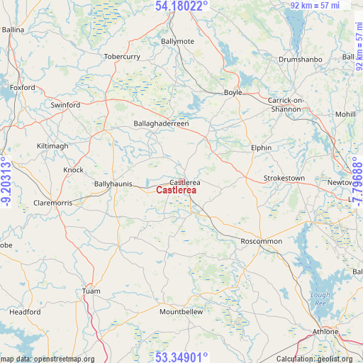
Castlerea GPS coordinates[2]
53° 46' 0.012" North, 8° 30' 0" West
| Map corner | latitude | longitude |
|---|---|---|
| Upper-left | 54.18022°, | -9.20313° |
| Center: | 53.76667°, | -8.5° |
| Lower-right: | 53.34901°, | -7.79688° |
| Map W x H: | 92.4×92.4 km | = 57.4×57.4mi |
| max Lat: | 55.25° ⇑19.7% North |
| Castlerea: | 53.76667° |
| min Lat: | ⇓80.3% South 51.52487° |
| min Long | Castlerea | max Long |
| -10.26889° | -8.5° | -6.04944° |
| W 25%⇐ | ⇒75% E |
Elevation
Elevation of Castlerea is 63 m = 207 ft, and this is 8.5 m = 28 ft above average elevation for this country.
| Max E: |
262 m = 860 ft | 36.1% |
| Castlerea | 63 m 207 ft | |
| Avg. | 54.5 m = 179 ft | |
Min E: |
0 m = 0 ft | 63.9% |
See also: Ireland elevation on elevation.city.
Geographical zone
Castlerea is located in North temperate zone (between Tropic of Cancer and the Arctic Circle). Distance of this North polar circle is 1422.9 km =884.1 mi to North.| Distance of | km | miles | from Castlerea |
|---|---|---|---|
| North Pole | 4028.8 | 2503.4 | to North |
| Arctic Circle | 1422.9 | 884.1 | to North |
| Tropic Cancer | 3372.4 | 2095.5 | to South |
| Equator | 5978.3 | 3714.7 | to South |


Nearby cities:
15 places around Castlerea: (largest is in red/bold)
• Ballaghaderreen
15.8 km =9.8 mi,  339°
339°
• Ballygar
29.5 km =18.3 mi,  157°
157°
• Ballyhaunis
17.5 km =10.9 mi,  270°
270°
• Boyle
25.8 km =16 mi,  30°
30°
• Carrick-on-Shannon
33.5 km =20.8 mi,  53°
53°
• Charlestown
29.2 km =18.1 mi,  318°
318°
• Claremorris
33.3 km =20.7 mi,  260°
260°
• Dunmore
22.7 km =14.1 mi,  222°
222°
• Elphin
21.8 km =13.5 mi,  64°
64°
• Kiltamagh
34.1 km =21.2 mi,  285°
285°
• Knock
27.8 km =17.3 mi,  275°
275°
• Mountbellew
32.8 km =20.4 mi,  180°
180°
• Moylough
31.8 km =19.8 mi,  187°
187°
• Roscommon
25.6 km =15.9 mi,  125°
125°
• Strokestown
26.3 km =16.3 mi,  85°
85°
Sources, notices
• [Note1] Compared only with cities in Ireland existing in our database
• [Src1] Map data: © OpenStreetMap contributors (CC-BY-SA)
• [Src2] Other city data from geonames.org with taken over terms of usage.
• [Src3] Geographical zone / Annual Mean Temperature by Robert A. Rohde @ Wikipedia
