Elphin geodata
Elphin (Connaught) is a populated place; located in Ireland in Europe/Dublin (GMT+1) time zone. With population of 613 people, there are 476 cities with bigger population in this country. Compared to other cities in Ireland, 83.1% of cities are located further ↓South; 66.4% of cities are located further →East and 82.4% of cities have lower elevation than Elphin. Note1


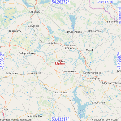
Elphin GPS coordinates[2]
53° 51' 0" North, 8° 12' 0" West
| Map corner | latitude | longitude |
|---|---|---|
| Upper-left | 54.26272°, | -8.90312° |
| Center: | 53.85°, | -8.2° |
| Lower-right: | 53.43317°, | -7.49687° |
| Map W x H: | 92.2×92.2 km | = 57.3×57.3mi |
| max Lat: | 55.25° ⇑16.9% North |
| Elphin: | 53.85° |
| min Lat: | ⇓83.1% South 51.52487° |
| min Long | Elphin | max Long |
| -10.26889° | -8.2° | -6.04944° |
| W 33.6%⇐ | ⇒66.4% E |
Elevation
Elevation of Elphin is 92 m = 302 ft, and this is 37.5 m = 123 ft above average elevation for this country.
| Max E: |
262 m = 860 ft | 17.6% |
| Elphin | 92 m 302 ft | |
| Avg. | 54.5 m = 179 ft | |
Min E: |
0 m = 0 ft | 82.4% |
See also: Ireland elevation on elevation.city.
Geographical zone
Elphin is located in North temperate zone (between Tropic of Cancer and the Arctic Circle). Distance of this North polar circle is 1413.6 km =878.4 mi to North.| Distance of | km | miles | from Elphin |
|---|---|---|---|
| North Pole | 4019.5 | 2497.6 | to North |
| Arctic Circle | 1413.6 | 878.4 | to North |
| Tropic Cancer | 3381.6 | 2101.2 | to South |
| Equator | 5987.6 | 3720.5 | to South |


Nearby cities:
15 places around Elphin: (largest is in red/bold)
• Ballaghaderreen
25.7 km =16 mi,  282°
282°
• Ballinamore
34.3 km =21.3 mi,  49°
49°
• Ballymote
33.2 km =20.6 mi,  321°
321°
• Boyle
14.5 km =9 mi,  333°
333°
• Carrick-on-Shannon
13 km =8.1 mi,  33°
33°
• Castlerea
21.8 km =13.5 mi,  244°
244°
• Drumlish
28.7 km =17.8 mi,  97°
97°
• Drumshanbo
24.8 km =15.4 mi, 26°
• Lanesborough
24.9 km =15.5 mi,  145°
145°
• Longford
29.8 km =18.5 mi,  117°
117°
• Mohill
23.1 km =14.4 mi,  71°
71°
• Newtownforbes
25.8 km =16 mi,  110°
110°
• Roosky
18.7 km =11.6 mi, 95°
• Roscommon
24.1 km =15 mi,  177°
177°
• Strokestown
9.9 km =6.2 mi,  138°
138°
Sources, notices
• [Note1] Compared only with cities in Ireland existing in our database
• [Src1] Map data: © OpenStreetMap contributors (CC-BY-SA)
• [Src2] Other city data from geonames.org with taken over terms of usage.
• [Src3] Geographical zone / Annual Mean Temperature by Robert A. Rohde @ Wikipedia
