Longford geodata
Longford (Leinster) is a seat of a second-order administrative division; located in Ireland in Europe/Dublin (GMT+1) time zone. With population of 7,787 people, there are 84 cities with bigger population in this country. Compared to other cities in Ireland, 79.1% of cities are located further ↓South; 58.6% of cities are located further →East and 51.6% of cities have lower elevation than Longford. Note1


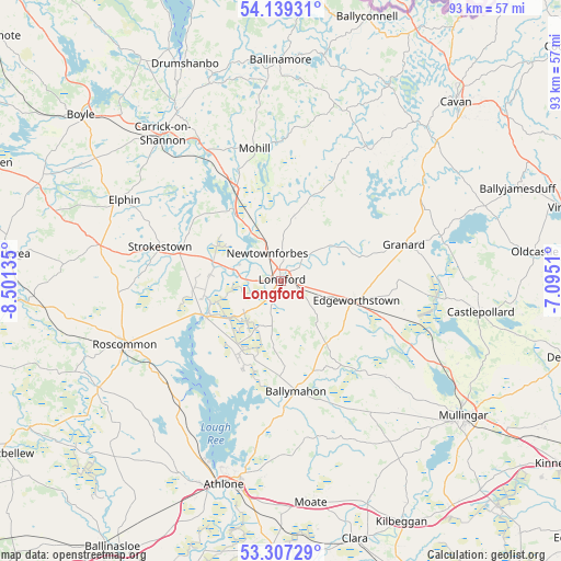
Longford GPS coordinates[2]
53° 43' 31.296" North, 7° 47' 53.628" West
| Map corner | latitude | longitude |
|---|---|---|
| Upper-left | 54.13931°, | -8.50135° |
| Center: | 53.72536°, | -7.79823° |
| Lower-right: | 53.30729°, | -7.0951° |
| Map W x H: | 92.5×92.5 km | = 57.5×57.5mi |
| max Lat: | 55.25° ⇑20.9% North |
| Longford: | 53.72536° |
| min Lat: | ⇓79.1% South 51.52487° |
| min Long | Longford | max Long |
| -10.26889° | -7.79823° | -6.04944° |
| W 41.4%⇐ | ⇒58.6% E |
Elevation
Elevation of Longford is 53 m = 174 ft, and this is 1.5 m = 5 ft below average elevation for this country.
| Max E: |
262 m = 860 ft | 48.4% |
| Avg. | 54.5 m = 179 ft | |
| Longford | 53 m = 174 ft | |
Min E: |
0 m = 0 ft | 51.6% |
See also: Ireland elevation on elevation.city.
Geographical zone
Longford is located in North temperate zone (between Tropic of Cancer and the Arctic Circle). Distance of this North polar circle is 1427.5 km =887 mi to North.| Distance of | km | miles | from Longford |
|---|---|---|---|
| North Pole | 4033.4 | 2506.2 | to North |
| Arctic Circle | 1427.5 | 887 | to North |
| Tropic Cancer | 3367.8 | 2092.7 | to South |
| Equator | 5973.7 | 3711.9 | to South |


Nearby cities:
15 places around Longford: (largest is in red/bold)
• Athlone
34 km =21.1 mi,  197°
197°
• Ballymahon
17.8 km =11.1 mi,  173°
173°
• Carrick-on-Shannon
31.2 km =19.4 mi,  322°
322°
• Castlepollard
33.4 km =20.8 mi,  98°
98°
• Drumlish
10.4 km =6.5 mi,  11°
11°
• Edgeworthstown
12.3 km =7.6 mi, 103°
• Elphin
29.8 km =18.5 mi,  297°
297°
• Granard
20.9 km =13 mi,  73°
73°
• Lanesborough
13.8 km =8.6 mi,  241°
241°
• Moate
20.2 km =12.6 mi,  164°
164°
• Mohill
21.7 km =13.5 mi,  348°
348°
• Newtownforbes
5.2 km =3.2 mi,  333°
333°
• Roosky
14.3 km =8.9 mi, 327°
• Roscommon
27.3 km =17 mi,  248°
248°
• Strokestown
20.9 km =13 mi,  287°
287°
Sources, notices
• [Note1] Compared only with cities in Ireland existing in our database
• [Src1] Map data: © OpenStreetMap contributors (CC-BY-SA)
• [Src2] Other city data from geonames.org with taken over terms of usage.
• [Src3] Geographical zone / Annual Mean Temperature by Robert A. Rohde @ Wikipedia
