Newtownforbes geodata
Newtownforbes (Leinster) is a populated place; located in Ireland in Europe/Dublin (GMT+1) time zone. With population of 759 people, there are 415 cities with bigger population in this country. Compared to other cities in Ireland, 80.6% of cities are located further ↓South; 59.6% of cities are located further →East and 57.7% of cities have lower elevation than Newtownforbes. Note1


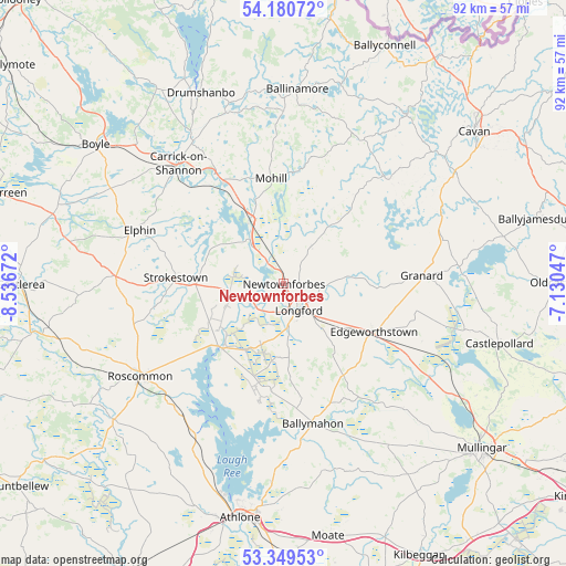
Newtownforbes GPS coordinates[2]
53° 46' 1.848" North, 7° 50' 0.96" West
| Map corner | latitude | longitude |
|---|---|---|
| Upper-left | 54.18072°, | -8.53672° |
| Center: | 53.76718°, | -7.8336° |
| Lower-right: | 53.34953°, | -7.13047° |
| Map W x H: | 92.4×92.4 km | = 57.4×57.4mi |
| max Lat: | 55.25° ⇑19.4% North |
| Newtownforbes: | 53.76718° |
| min Lat: | ⇓80.6% South 51.52487° |
| min Long | Newtownforbes | max Long |
| -10.26889° | -7.8336° | -6.04944° |
| W 40.4%⇐ | ⇒59.6% E |
Elevation
Elevation of Newtownforbes is 58 m = 190 ft, and this is 3.5 m = 11 ft above average elevation for this country.
| Max E: |
262 m = 860 ft | 42.3% |
| Newtownforbes | 58 m 190 ft | |
| Avg. | 54.5 m = 179 ft | |
Min E: |
0 m = 0 ft | 57.7% |
See also: Ireland elevation on elevation.city.
Geographical zone
Newtownforbes is located in North temperate zone (between Tropic of Cancer and the Arctic Circle). Distance of this North polar circle is 1422.8 km =884.1 mi to North.| Distance of | km | miles | from Newtownforbes |
|---|---|---|---|
| North Pole | 4028.7 | 2503.3 | to North |
| Arctic Circle | 1422.8 | 884.1 | to North |
| Tropic Cancer | 3372.4 | 2095.5 | to South |
| Equator | 5978.3 | 3714.7 | to South |


Nearby cities:
15 places around Newtownforbes: (largest is in red/bold)
• Ballinagh
33 km =20.5 mi,  55°
55°
• Ballinamore
31.5 km =19.6 mi,  4°
4°
• Ballymahon
22.7 km =14.1 mi,  168°
168°
• Carrick-on-Shannon
26.1 km =16.2 mi,  319°
319°
• Drumlish
7 km =4.3 mi,  38°
38°
• Edgeworthstown
16.1 km =10 mi,  117°
117°
• Elphin
25.8 km =16 mi,  290°
290°
• Granard
22.3 km =13.9 mi,  86°
86°
• Lanesborough
14.9 km =9.3 mi,  221°
221°
• Longford
5.2 km =3.2 mi,  153°
153°
• Moate
25.3 km =15.7 mi,  162°
162°
• Mohill
16.8 km =10.4 mi,  352°
352°
• Roosky
9.2 km =5.7 mi, 323°
• Roscommon
27.4 km =17 mi,  237°
237°
• Strokestown
17.6 km =10.9 mi,  275°
275°
Sources, notices
• [Note1] Compared only with cities in Ireland existing in our database
• [Src1] Map data: © OpenStreetMap contributors (CC-BY-SA)
• [Src2] Other city data from geonames.org with taken over terms of usage.
• [Src3] Geographical zone / Annual Mean Temperature by Robert A. Rohde @ Wikipedia
