Ballygar geodata
Ballygar (Connaught) is a populated place; located in Ireland in Europe/Dublin (GMT+1) time zone. With population of 660 people, there are 451 cities with bigger population in this country. Compared to other cities in Ireland, 72.7% of cities are located further ↓South; 70.4% of cities are located further →East and 58.4% of cities have lower elevation than Ballygar. Note1


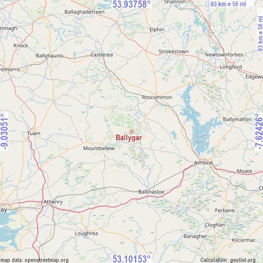
Ballygar GPS coordinates[2]
53° 31' 17.832" North, 8° 19' 38.568" West
| Map corner | latitude | longitude |
|---|---|---|
| Upper-left | 53.93758°, | -9.03051° |
| Center: | 53.52162°, | -8.32738° |
| Lower-right: | 53.10153°, | -7.62426° |
| Map W x H: | 93×93 km | = 57.8×57.8mi |
| max Lat: | 55.25° ⇑27.3% North |
| Ballygar: | 53.52162° |
| min Lat: | ⇓72.7% South 51.52487° |
| min Long | Ballygar | max Long |
| -10.26889° | -8.32738° | -6.04944° |
| W 29.6%⇐ | ⇒70.4% E |
Elevation
Elevation of Ballygar is 59 m = 194 ft, and this is 4.5 m = 15 ft above average elevation for this country.
| Max E: |
262 m = 860 ft | 41.6% |
| Ballygar | 59 m 194 ft | |
| Avg. | 54.5 m = 179 ft | |
Min E: |
0 m = 0 ft | 58.4% |
See also: Ireland elevation on elevation.city.
Geographical zone
Ballygar is located in North temperate zone (between Tropic of Cancer and the Arctic Circle). Distance of this North polar circle is 1450.1 km =901.1 mi to North.| Distance of | km | miles | from Ballygar |
|---|---|---|---|
| North Pole | 4056 | 2520.3 | to North |
| Arctic Circle | 1450.1 | 901.1 | to North |
| Tropic Cancer | 3345.1 | 2078.5 | to South |
| Equator | 5951 | 3697.8 | to South |


Nearby cities:
15 places around Ballygar: (largest is in red/bold)
• Athenry
37.2 km =23.1 mi,  227°
227°
• Athlone
26.8 km =16.7 mi,  111°
111°
• Ballinasloe
22.7 km =14.1 mi,  161°
161°
• Ballymahon
37.4 km =23.2 mi,  82°
82°
• Castlerea
29.5 km =18.3 mi,  337°
337°
• Corrofin
36.8 km =22.9 mi,  255°
255°
• Dunmore
28.8 km =17.9 mi,  291°
291°
• Elphin
37.5 km =23.3 mi,  12°
12°
• Lanesborough
27.8 km =17.3 mi,  54°
54°
• Loughrea
39.4 km =24.5 mi,  203°
203°
• Mountbellew
12.9 km =8 mi,  244°
244°
• Moylough
16.4 km =10.2 mi,  254°
254°
• Roscommon
15.6 km =9.7 mi,  37°
37°
• Strokestown
32.7 km =20.3 mi,  27°
27°
• Tuam
34.6 km =21.5 mi,  269°
269°
Sources, notices
• [Note1] Compared only with cities in Ireland existing in our database
• [Src1] Map data: © OpenStreetMap contributors (CC-BY-SA)
• [Src2] Other city data from geonames.org with taken over terms of usage.
• [Src3] Geographical zone / Annual Mean Temperature by Robert A. Rohde @ Wikipedia
