Robertstown geodata
Robertstown (Leinster) is a populated place; located in Ireland in Europe/Dublin (GMT+1) time zone. With population of 669 people, there are 446 cities with bigger population in this country. Compared to other cities in Ireland, 51.2% of cities are located further ↓South; 65.1% of cities are located further ←West and 74.6% of cities have lower elevation than Robertstown. Note1


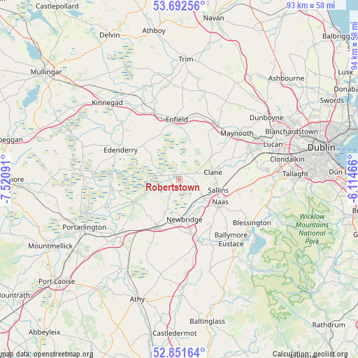
Robertstown GPS coordinates[2]
53° 16' 27.012" North, 6° 49' 4.008" West
| Map corner | latitude | longitude |
|---|---|---|
| Upper-left | 53.69256°, | -7.52091° |
| Center: | 53.27417°, | -6.81778° |
| Lower-right: | 52.85164°, | -6.11466° |
| Map W x H: | 93.5×93.5 km | = 58.1×58.1mi |
| max Lat: | 55.25° ⇑48.8% North |
| Robertstown: | 53.27417° |
| min Lat: | ⇓51.2% South 51.52487° |
| min Long | Robertstown | max Long |
| -10.26889° | -6.81778° | -6.04944° |
| W 65.1%⇐ | ⇒34.9% E |
Elevation
Elevation of Robertstown is 78 m = 256 ft, and this is 23.5 m = 77 ft above average elevation for this country.
| Max E: |
262 m = 860 ft | 25.4% |
| Robertstown | 78 m 256 ft | |
| Avg. | 54.5 m = 179 ft | |
Min E: |
0 m = 0 ft | 74.6% |
See also: Ireland elevation on elevation.city.
Geographical zone
Robertstown is located in North temperate zone (between Tropic of Cancer and the Arctic Circle). Distance of this North polar circle is 1477.6 km =918.1 mi to North.| Distance of | km | miles | from Robertstown |
|---|---|---|---|
| North Pole | 4083.5 | 2537.4 | to North |
| Arctic Circle | 1477.6 | 918.1 | to North |
| Tropic Cancer | 3317.6 | 2061.5 | to South |
| Equator | 5923.5 | 3680.7 | to South |


Nearby cities:
15 places around Robertstown: (largest is in red/bold)
• Allenwood Cross Roads
3.1 km =1.9 mi,  290°
290°
• Athgarvan
13.8 km =8.6 mi,  169°
169°
• Blackwood
2.1 km =1.3 mi,  358°
358°
• Carragh
7.3 km =4.5 mi,  125°
125°
• Clane
8.8 km =5.5 mi,  77°
77°
• Derrinturn
11.1 km =6.9 mi,  312°
312°
• Droichead Nua
10.4 km =6.5 mi, 172°
• Johnstown
13.6 km =8.5 mi,  107°
107°
• Kildare
14.6 km =9.1 mi,  206°
206°
• Kilmeage
2.9 km =1.8 mi, 213°
• Naas
12 km =7.5 mi,  122°
122°
• Prosperous
4.6 km =2.9 mi,  67°
67°
• Rathangan
13.2 km =8.2 mi,  243°
243°
• Sallins
10.5 km =6.5 mi, 105°
• Straffan
14.3 km =8.9 mi, 71°
Sources, notices
• [Note1] Compared only with cities in Ireland existing in our database
• [Src1] Map data: © OpenStreetMap contributors (CC-BY-SA)
• [Src2] Other city data from geonames.org with taken over terms of usage.
• [Src3] Geographical zone / Annual Mean Temperature by Robert A. Rohde @ Wikipedia
