Athgarvan geodata
Athgarvan (Leinster) is a populated place; located in Ireland in Europe/Dublin (GMT+1) time zone. With population of 1,016 people, there are 348 cities with bigger population in this country. Compared to other cities in Ireland, 55.2% of cities are located further ↑North; 66.2% of cities are located further ←West and 86.1% of cities have lower elevation than Athgarvan. Note1


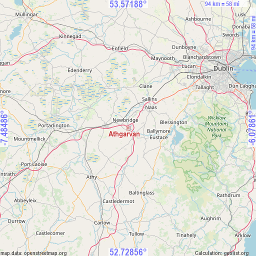
Athgarvan GPS coordinates[2]
53° 9' 8.244" North, 6° 46' 54.228" West
| Map corner | latitude | longitude |
|---|---|---|
| Upper-left | 53.57188°, | -7.48486° |
| Center: | 53.15229°, | -6.78173° |
| Lower-right: | 52.72856°, | -6.07861° |
| Map W x H: | 93.8×93.8 km | = 58.3×58.3mi |
| max Lat: | 55.25° ⇑55.2% North |
| Athgarvan: | 53.15229° |
| min Lat: | ⇓44.8% South 51.52487° |
| min Long | Athgarvan | max Long |
| -10.26889° | -6.78173° | -6.04944° |
| W 66.2%⇐ | ⇒33.8% E |
Elevation
Elevation of Athgarvan is 98 m = 322 ft, and this is 43.5 m = 143 ft above average elevation for this country.
| Max E: |
262 m = 860 ft | 13.9% |
| Athgarvan | 98 m 322 ft | |
| Avg. | 54.5 m = 179 ft | |
Min E: |
0 m = 0 ft | 86.1% |
See also: Ireland elevation on elevation.city.
Geographical zone
Athgarvan is located in North temperate zone (between Tropic of Cancer and the Arctic Circle). Distance of this North polar circle is 1491.2 km =926.6 mi to North.| Distance of | km | miles | from Athgarvan |
|---|---|---|---|
| North Pole | 4097.1 | 2545.8 | to North |
| Arctic Circle | 1491.2 | 926.6 | to North |
| Tropic Cancer | 3304.1 | 2053.1 | to South |
| Equator | 5910 | 3672.3 | to South |


Nearby cities:
15 places around Athgarvan: (largest is in red/bold)
• Ballymore Eustace
11.2 km =7 mi,  100°
100°
• Brownstown Cross Roads
4.2 km =2.6 mi,  248°
248°
• Calverstown
7.8 km =4.8 mi,  187°
187°
• Carragh
10 km =6.2 mi,  20°
20°
• Cherryville
12.3 km =7.6 mi,  272°
272°
• Droichead Nua
3.4 km =2.1 mi,  343°
343°
• Dunlavin
11.9 km =7.4 mi,  154°
154°
• Kilcullen
3.5 km =2.2 mi,  134°
134°
• Kildare
8.9 km =5.5 mi, 272°
• Kilmeage
11.8 km =7.3 mi, 340°
• Naas
10.4 km =6.5 mi,  47°
47°
• Old Kilcullen
5.2 km =3.2 mi,  167°
167°
• Robertstown
13.8 km =8.6 mi,  349°
349°
• Sallins
13.2 km =8.2 mi,  35°
35°
• Suncroft
7.5 km =4.7 mi,  224°
224°
Sources, notices
• [Note1] Compared only with cities in Ireland existing in our database
• [Src1] Map data: © OpenStreetMap contributors (CC-BY-SA)
• [Src2] Other city data from geonames.org with taken over terms of usage.
• [Src3] Geographical zone / Annual Mean Temperature by Robert A. Rohde @ Wikipedia
