Naas geodata
Naas (Leinster) is a seat of a second-order administrative division; located in Ireland in Europe/Dublin (GMT+1) time zone. With population of 20,713 people, there are 16 cities with bigger population in this country. Compared to other cities in Ireland, 52.6% of cities are located further ↑North; 69.4% of cities are located further ←West and 83.5% of cities have lower elevation than Naas. Note1


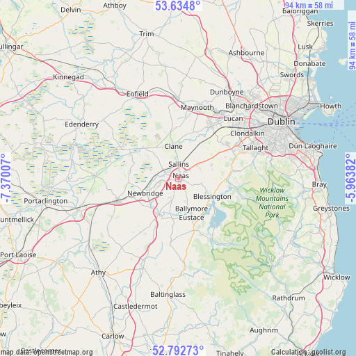
Naas GPS coordinates[2]
53° 12' 56.988" North, 6° 40' 0.984" West
| Map corner | latitude | longitude |
|---|---|---|
| Upper-left | 53.6348°, | -7.37007° |
| Center: | 53.21583°, | -6.66694° |
| Lower-right: | 52.79273°, | -5.96382° |
| Map W x H: | 93.6×93.6 km | = 58.2×58.2mi |
| max Lat: | 55.25° ⇑52.6% North |
| Naas: | 53.21583° |
| min Lat: | ⇓47.4% South 51.52487° |
| min Long | Naas | max Long |
| -10.26889° | -6.66694° | -6.04944° |
| W 69.4%⇐ | ⇒30.6% E |
Elevation
Elevation of Naas is 93 m = 305 ft, and this is 38.5 m = 126 ft above average elevation for this country.
| Max E: |
262 m = 860 ft | 16.5% |
| Naas | 93 m 305 ft | |
| Avg. | 54.5 m = 179 ft | |
Min E: |
0 m = 0 ft | 83.5% |
See also: Ireland elevation on elevation.city.
Geographical zone
Naas is located in North temperate zone (between Tropic of Cancer and the Arctic Circle). Distance of this North polar circle is 1484.1 km =922.2 mi to North.| Distance of | km | miles | from Naas |
|---|---|---|---|
| North Pole | 4090 | 2541.4 | to North |
| Arctic Circle | 1484.1 | 922.2 | to North |
| Tropic Cancer | 3311.1 | 2057.4 | to South |
| Equator | 5917 | 3676.7 | to South |


Nearby cities:
15 places around Naas: (largest is in red/bold)
• Athgarvan
10.4 km =6.5 mi,  227°
227°
• Ballymore Eustace
9.8 km =6.1 mi,  159°
159°
• Blessington
10.3 km =6.4 mi,  119°
119°
• Carragh
4.7 km =2.9 mi,  299°
299°
• Clane
8.5 km =5.3 mi,  350°
350°
• Droichead Nua
9.4 km =5.8 mi,  246°
246°
• Eadestown
6.1 km =3.8 mi,  103°
103°
• Johnstown
3.9 km =2.4 mi,  49°
49°
• Kilcullen
10.8 km =6.7 mi,  208°
208°
• Kill
6.4 km =4 mi, 51°
• Kilmeage
12.3 km =7.6 mi,  289°
289°
• Prosperous
10.1 km =6.3 mi,  325°
325°
• Robertstown
12 km =7.5 mi, 302°
• Sallins
3.7 km =2.3 mi,  0°
0°
• Straffan
11.5 km =7.1 mi,  17°
17°
Sources, notices
• [Note1] Compared only with cities in Ireland existing in our database
• [Src1] Map data: © OpenStreetMap contributors (CC-BY-SA)
• [Src2] Other city data from geonames.org with taken over terms of usage.
• [Src3] Geographical zone / Annual Mean Temperature by Robert A. Rohde @ Wikipedia
