Straffan geodata
Straffan (Leinster) is a populated place; located in Ireland in Europe/Dublin (GMT+1) time zone. With population of 635 people, there are 460 cities with bigger population in this country. Compared to other cities in Ireland, 56.9% of cities are located further ↓South; 70.8% of cities are located further ←West and 70.2% of cities have lower elevation than Straffan. Note1


Straffan GPS coordinates[2]
53° 18' 50.4" North, 6° 36' 49.428" West
| Map corner | latitude | longitude |
|---|---|---|
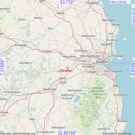
| Upper-left | 53.732°, | -7.31686° |
| Center: | 53.314°, | -6.61373° |
| Lower-right: | 52.89186°, | -5.91061° |
| Map W x H: | 93.4×93.4 km | = 58×58mi |
| max Lat: | 55.25° ⇑43.1% North |
| Straffan: | 53.314° |
| min Lat: | ⇓56.9% South 51.52487° |
| min Long | Straffan | max Long |
| -10.26889° | -6.61373° | -6.04944° |
| W 70.8%⇐ | ⇒29.2% E |
Elevation
Elevation of Straffan is 71 m = 233 ft, and this is 16.5 m = 54 ft above average elevation for this country.
| Max E: |
262 m = 860 ft | 29.8% |
| Straffan | 71 m 233 ft | |
| Avg. | 54.5 m = 179 ft | |
Min E: |
0 m = 0 ft | 70.2% |
See also: Ireland elevation on elevation.city.
Geographical zone
Straffan is located in North temperate zone (between Tropic of Cancer and the Arctic Circle). Distance of this North polar circle is 1473.2 km =915.4 mi to North.| Distance of | km | miles | from Straffan |
|---|---|---|---|
| North Pole | 4079.1 | 2534.6 | to North |
| Arctic Circle | 1473.2 | 915.4 | to North |
| Tropic Cancer | 3322 | 2064.2 | to South |
| Equator | 5928 | 3683.5 | to South |


Nearby cities:
15 places around Straffan: (largest is in red/bold)
• Carragh
11.5 km =7.1 mi,  221°
221°
• Celbridge
5.5 km =3.4 mi,  56°
56°
• Clane
5.6 km =3.5 mi,  243°
243°
• Confey
10.9 km =6.8 mi,  48°
48°
• Johnstown
8.4 km =5.2 mi,  183°
183°
• Kilcock
10.5 km =6.5 mi,  338°
338°
• Kill
7.1 km =4.4 mi,  168°
168°
• Leixlip
9.7 km =6 mi, 53°
• Maynooth
8 km =5 mi,  9°
9°
• Naas
11.5 km =7.1 mi,  197°
197°
• Newcastle
7.5 km =4.7 mi,  100°
100°
• Prosperous
9.7 km =6 mi,  254°
254°
• Rathcoole
10 km =6.2 mi,  110°
110°
• Saggart
11.9 km =7.4 mi, 108°
• Sallins
8 km =5 mi,  205°
205°
Sources, notices
• [Note1] Compared only with cities in Ireland existing in our database
• [Src1] Map data: © OpenStreetMap contributors (CC-BY-SA)
• [Src2] Other city data from geonames.org with taken over terms of usage.
• [Src3] Geographical zone / Annual Mean Temperature by Robert A. Rohde @ Wikipedia
