Johnstown geodata
Johnstown (Leinster) is a populated place; located in Ireland in Europe/Dublin (GMT+1) time zone. With population of 1,004 people, there are 350 cities with bigger population in this country. Compared to other cities in Ireland, 51.4% of cities are located further ↑North; 70.4% of cities are located further ←West and 80.8% of cities have lower elevation than Johnstown. Note1


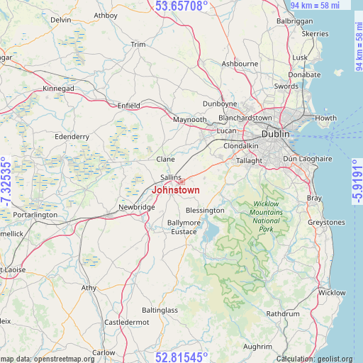
Johnstown GPS coordinates[2]
53° 14' 17.988" North, 6° 37' 19.992" West
| Map corner | latitude | longitude |
|---|---|---|
| Upper-left | 53.65708°, | -7.32535° |
| Center: | 53.23833°, | -6.62222° |
| Lower-right: | 52.81545°, | -5.9191° |
| Map W x H: | 93.6×93.6 km | = 58.2×58.2mi |
| max Lat: | 55.25° ⇑51.4% North |
| Johnstown: | 53.23833° |
| min Lat: | ⇓48.6% South 51.52487° |
| min Long | Johnstown | max Long |
| -10.26889° | -6.62222° | -6.04944° |
| W 70.4%⇐ | ⇒29.6% E |
Elevation
Elevation of Johnstown is 90 m = 295 ft, and this is 35.5 m = 116 ft above average elevation for this country.
| Max E: |
262 m = 860 ft | 19.2% |
| Johnstown | 90 m 295 ft | |
| Avg. | 54.5 m = 179 ft | |
Min E: |
0 m = 0 ft | 80.8% |
See also: Ireland elevation on elevation.city.
Geographical zone
Johnstown is located in North temperate zone (between Tropic of Cancer and the Arctic Circle). Distance of this North polar circle is 1481.6 km =920.6 mi to North.| Distance of | km | miles | from Johnstown |
|---|---|---|---|
| North Pole | 4087.5 | 2539.9 | to North |
| Arctic Circle | 1481.6 | 920.6 | to North |
| Tropic Cancer | 3313.6 | 2059 | to South |
| Equator | 5919.5 | 3678.2 | to South |


Nearby cities:
15 places around Johnstown: (largest is in red/bold)
• Ballymore Eustace
11.7 km =7.3 mi,  178°
178°
• Blessington
9.7 km =6 mi,  141°
141°
• Carragh
7.1 km =4.4 mi,  268°
268°
• Celbridge
12.6 km =7.8 mi,  24°
24°
• Clane
7.4 km =4.6 mi,  322°
322°
• Droichead Nua
13.2 km =8.2 mi,  241°
241°
• Eadestown
4.9 km =3 mi, 143°
• Kill
2.5 km =1.6 mi,  54°
54°
• Naas
3.9 km =2.4 mi,  229°
229°
• Newcastle
10.6 km =6.6 mi, 48°
• Prosperous
10.5 km =6.5 mi,  303°
303°
• Rathcoole
11.1 km =6.9 mi,  63°
63°
• Saggart
12.7 km =7.9 mi,  68°
68°
• Sallins
3.1 km =1.9 mi,  291°
291°
• Straffan
8.4 km =5.2 mi,  3°
3°
Sources, notices
• [Note1] Compared only with cities in Ireland existing in our database
• [Src1] Map data: © OpenStreetMap contributors (CC-BY-SA)
• [Src2] Other city data from geonames.org with taken over terms of usage.
• [Src3] Geographical zone / Annual Mean Temperature by Robert A. Rohde @ Wikipedia
