Derrinturn geodata
Derrinturn (Leinster) is a populated place; located in Ireland in Europe/Dublin (GMT+1) time zone. With population of 1,541 people, there are 270 cities with bigger population in this country. Compared to other cities in Ireland, 60% of cities are located further ↓South; 61.3% of cities are located further ←West and 78.4% of cities have lower elevation than Derrinturn. Note1


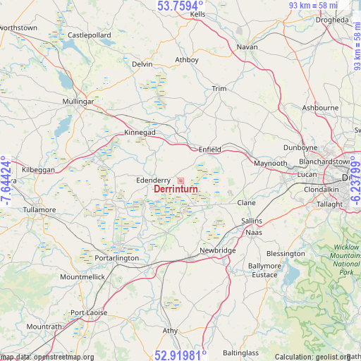
Derrinturn GPS coordinates[2]
53° 20' 30.012" North, 6° 56' 27.996" West
| Map corner | latitude | longitude |
|---|---|---|
| Upper-left | 53.7594°, | -7.64424° |
| Center: | 53.34167°, | -6.94111° |
| Lower-right: | 52.91981°, | -6.23799° |
| Map W x H: | 93.4×93.4 km | = 58×58mi |
| max Lat: | 55.25° ⇑40% North |
| Derrinturn: | 53.34167° |
| min Lat: | ⇓60% South 51.52487° |
| min Long | Derrinturn | max Long |
| -10.26889° | -6.94111° | -6.04944° |
| W 61.3%⇐ | ⇒38.7% E |
Elevation
Elevation of Derrinturn is 86 m = 282 ft, and this is 31.5 m = 103 ft above average elevation for this country.
| Max E: |
262 m = 860 ft | 21.6% |
| Derrinturn | 86 m 282 ft | |
| Avg. | 54.5 m = 179 ft | |
Min E: |
0 m = 0 ft | 78.4% |
See also: Ireland elevation on elevation.city.
Geographical zone
Derrinturn is located in North temperate zone (between Tropic of Cancer and the Arctic Circle). Distance of this North polar circle is 1470.1 km =913.5 mi to North.| Distance of | km | miles | from Derrinturn |
|---|---|---|---|
| North Pole | 4076 | 2532.7 | to North |
| Arctic Circle | 1470.1 | 913.5 | to North |
| Tropic Cancer | 3325.1 | 2066.1 | to South |
| Equator | 5931 | 3685.4 | to South |


Nearby cities:
15 places around Derrinturn: (largest is in red/bold)
• Allenwood Cross Roads
8.3 km =5.2 mi,  140°
140°
• Blackwood
9.8 km =6.1 mi,  123°
123°
• Carragh
18.4 km =11.4 mi,  129°
129°
• Clane
17.6 km =10.9 mi,  108°
108°
• Edenderry
7.1 km =4.4 mi,  268°
268°
• Enfield
10.8 km =6.7 mi,  41°
41°
• Johnstown Bridge
8.8 km =5.5 mi, 38°
• Kilcock
19.2 km =11.9 mi,  69°
69°
• Kilmeage
12 km =7.5 mi,  146°
146°
• Kinnegad
16.2 km =10.1 mi,  319°
319°
• Longwood
12.5 km =7.8 mi,  5°
5°
• Prosperous
13.7 km =8.5 mi, 114°
• Rathangan
13.8 km =8.6 mi,  194°
194°
• Rhode
17.3 km =10.7 mi, 273°
• Robertstown
11.1 km =6.9 mi, 132°
Sources, notices
• [Note1] Compared only with cities in Ireland existing in our database
• [Src1] Map data: © OpenStreetMap contributors (CC-BY-SA)
• [Src2] Other city data from geonames.org with taken over terms of usage.
• [Src3] Geographical zone / Annual Mean Temperature by Robert A. Rohde @ Wikipedia
