Kilmeage geodata
Kilmeage (Leinster) is a populated place; located in Ireland in Europe/Dublin (GMT+1) time zone. With population of 997 people, there are 351 cities with bigger population in this country. Compared to other cities in Ireland, 50.7% of cities are located further ↑North; 63.9% of cities are located further ←West and 93.7% of cities have lower elevation than Kilmeage. Note1


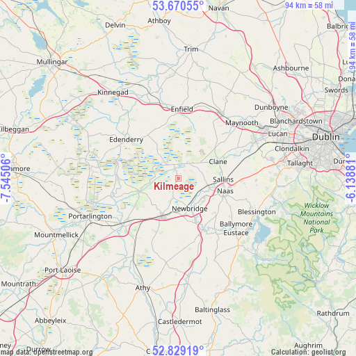
Kilmeage GPS coordinates[2]
53° 15' 6.984" North, 6° 50' 30.984" West
| Map corner | latitude | longitude |
|---|---|---|
| Upper-left | 53.67055°, | -7.54506° |
| Center: | 53.25194°, | -6.84194° |
| Lower-right: | 52.82919°, | -6.13881° |
| Map W x H: | 93.6×93.5 km | = 58.2×58.1mi |
| max Lat: | 55.25° ⇑50.7% North |
| Kilmeage: | 53.25194° |
| min Lat: | ⇓49.3% South 51.52487° |
| min Long | Kilmeage | max Long |
| -10.26889° | -6.84194° | -6.04944° |
| W 63.9%⇐ | ⇒36.1% E |
Elevation
Elevation of Kilmeage is 116 m = 381 ft, and this is 61.5 m = 202 ft above average elevation for this country.
| Max E: |
262 m = 860 ft | 6.3% |
| Kilmeage | 116 m 381 ft | |
| Avg. | 54.5 m = 179 ft | |
Min E: |
0 m = 0 ft | 93.7% |
See also: Ireland elevation on elevation.city.
Geographical zone
Kilmeage is located in North temperate zone (between Tropic of Cancer and the Arctic Circle). Distance of this North polar circle is 1480.1 km =919.7 mi to North.| Distance of | km | miles | from Kilmeage |
|---|---|---|---|
| North Pole | 4086 | 2538.9 | to North |
| Arctic Circle | 1480.1 | 919.7 | to North |
| Tropic Cancer | 3315.1 | 2059.9 | to South |
| Equator | 5921.1 | 3679.2 | to South |


Nearby cities:
15 places around Kilmeage: (largest is in red/bold)
• Allenwood Cross Roads
3.8 km =2.4 mi,  339°
339°
• Athgarvan
11.8 km =7.3 mi,  160°
160°
• Blackwood
4.8 km =3 mi,  18°
18°
• Brownstown Cross Roads
12.7 km =7.9 mi,  179°
179°
• Carragh
7.8 km =4.8 mi,  102°
102°
• Cherryville
13.4 km =8.3 mi,  218°
218°
• Clane
11.1 km =6.9 mi,  66°
66°
• Derrinturn
12 km =7.5 mi,  326°
326°
• Droichead Nua
8.3 km =5.2 mi, 158°
• Kildare
11.7 km =7.3 mi,  204°
204°
• Naas
12.3 km =7.6 mi,  109°
109°
• Prosperous
7.2 km =4.5 mi,  53°
53°
• Rathangan
10.7 km =6.6 mi,  251°
251°
• Robertstown
2.9 km =1.8 mi,  33°
33°
• Sallins
11.7 km =7.3 mi,  91°
91°
Sources, notices
• [Note1] Compared only with cities in Ireland existing in our database
• [Src1] Map data: © OpenStreetMap contributors (CC-BY-SA)
• [Src2] Other city data from geonames.org with taken over terms of usage.
• [Src3] Geographical zone / Annual Mean Temperature by Robert A. Rohde @ Wikipedia
