Rathard geodata
Rathard (Munster) is a populated place; located in Ireland in Europe/Dublin (GMT+1) time zone. With population of 560 people, there are 497 cities with bigger population in this country. Compared to other cities in Ireland, 96% of cities are located further ↑North; 82.7% of cities are located further →East and 89.4% of cities have lower elevation than Rathard. Note1


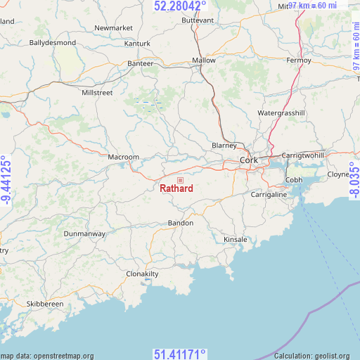
Rathard GPS coordinates[2]
51° 50' 53.376" North, 8° 44' 17.232" West
| Map corner | latitude | longitude |
|---|---|---|
| Upper-left | 52.28042°, | -9.44125° |
| Center: | 51.84816°, | -8.73812° |
| Lower-right: | 51.41171°, | -8.035° |
| Map W x H: | 96.6×96.6 km | = 60×60mi |
| max Lat: | 55.25° ⇑96% North |
| Rathard: | 51.84816° |
| min Lat: | ⇓4% South 51.52487° |
| min Long | Rathard | max Long |
| -10.26889° | -8.73812° | -6.04944° |
| W 17.3%⇐ | ⇒82.7% E |
Elevation
Elevation of Rathard is 103 m = 338 ft, and this is 48.5 m = 159 ft above average elevation for this country.
| Max E: |
262 m = 860 ft | 10.6% |
| Rathard | 103 m 338 ft | |
| Avg. | 54.5 m = 179 ft | |
Min E: |
0 m = 0 ft | 89.4% |
See also: Ireland elevation on elevation.city.
Geographical zone
Rathard is located in North temperate zone (between Tropic of Cancer and the Arctic Circle). Distance of this North polar circle is 1636.2 km =1016.7 mi to North.| Distance of | km | miles | from Rathard |
|---|---|---|---|
| North Pole | 4242.1 | 2635.9 | to North |
| Arctic Circle | 1636.2 | 1016.7 | to North |
| Tropic Cancer | 3159.1 | 1963 | to South |
| Equator | 5765 | 3582.2 | to South |


Nearby cities:
15 places around Rathard: (largest is in red/bold)
• Ballygarvan
19.2 km =11.9 mi,  98°
98°
• Bandon
11.3 km =7 mi,  181°
181°
• Belgooly
20.9 km =13 mi,  125°
125°
• Blarney
15.1 km =9.4 mi,  51°
51°
• Cork
19.2 km =11.9 mi,  73°
73°
• Courtbrack
14.6 km =9.1 mi,  25°
25°
• Enniskeane
18.1 km =11.2 mi,  227°
227°
• Grenagh
20.6 km =12.8 mi, 25°
• Innishannon
10.8 km =6.7 mi,  148°
148°
• Killumney
6.8 km =4.2 mi, 66°
• Kinsale
21.2 km =13.2 mi,  137°
137°
• Macroom
17.2 km =10.7 mi,  292°
292°
• Riverstick
18.8 km =11.7 mi,  116°
116°
• Tower
12.5 km =7.8 mi, 46°
• Whitechurch
21.4 km =13.3 mi, 46°
Sources, notices
• [Note1] Compared only with cities in Ireland existing in our database
• [Src1] Map data: © OpenStreetMap contributors (CC-BY-SA)
• [Src2] Other city data from geonames.org with taken over terms of usage.
• [Src3] Geographical zone / Annual Mean Temperature by Robert A. Rohde @ Wikipedia
