Killumney geodata
Killumney (Munster) is a populated place; located in Ireland in Europe/Dublin (GMT+1) time zone. With population of 1,046 people, there are 340 cities with bigger population in this country. Compared to other cities in Ireland, 95.3% of cities are located further ↑North; 80.1% of cities are located further →East and 61.7% of cities have higher elevation than Killumney. Note1


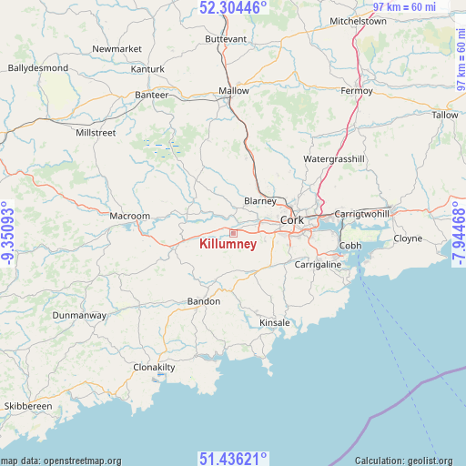
Killumney GPS coordinates[2]
51° 52' 20.748" North, 8° 38' 52.116" West
| Map corner | latitude | longitude |
|---|---|---|
| Upper-left | 52.30446°, | -9.35093° |
| Center: | 51.87243°, | -8.64781° |
| Lower-right: | 51.43621°, | -7.94468° |
| Map W x H: | 96.5×96.5 km | = 60×60mi |
| max Lat: | 55.25° ⇑95.3% North |
| Killumney: | 51.87243° |
| min Lat: | ⇓4.7% South 51.52487° |
| min Long | Killumney | max Long |
| -10.26889° | -8.64781° | -6.04944° |
| W 19.9%⇐ | ⇒80.1% E |
Elevation
Elevation of Killumney is 36 m = 118 ft, and this is 18.5 m = 61 ft below average elevation for this country.
| Max E: |
262 m = 860 ft | 61.7% |
| Avg. | 54.5 m = 179 ft | |
| Killumney | 36 m = 118 ft | |
Min E: |
0 m = 0 ft | 38.3% |
See also: Ireland elevation on elevation.city.
Geographical zone
Killumney is located in North temperate zone (between Tropic of Cancer and the Arctic Circle). Distance of this North polar circle is 1633.5 km =1015 mi to North.| Distance of | km | miles | from Killumney |
|---|---|---|---|
| North Pole | 4239.4 | 2634.2 | to North |
| Arctic Circle | 1633.5 | 1015 | to North |
| Tropic Cancer | 3161.8 | 1964.7 | to South |
| Equator | 5767.7 | 3583.9 | to South |


Nearby cities:
15 places around Killumney: (largest is in red/bold)
• Ballygarvan
13.9 km =8.6 mi,  113°
113°
• Bandon
15.4 km =9.6 mi,  205°
205°
• Belgooly
18.4 km =11.4 mi,  143°
143°
• Blarney
8.8 km =5.5 mi,  39°
39°
• Carrigaline
18.4 km =11.4 mi, 111°
• Cork
12.5 km =7.8 mi,  76°
76°
• Courtbrack
10.5 km =6.5 mi,  0°
0°
• Grenagh
16.1 km =10 mi,  9°
9°
• Innishannon
11.9 km =7.4 mi,  183°
183°
• Kinsale
20 km =12.4 mi,  156°
156°
• Passage West
20.8 km =12.9 mi,  89°
89°
• Rathard
6.8 km =4.2 mi,  246°
246°
• Riverstick
15.3 km =9.5 mi, 136°
• Tower
6.6 km =4.1 mi,  24°
24°
• Whitechurch
15.2 km =9.4 mi, 37°
Sources, notices
• [Note1] Compared only with cities in Ireland existing in our database
• [Src1] Map data: © OpenStreetMap contributors (CC-BY-SA)
• [Src2] Other city data from geonames.org with taken over terms of usage.
• [Src3] Geographical zone / Annual Mean Temperature by Robert A. Rohde @ Wikipedia
