Granard geodata
Granard (Leinster) is a populated place; located in Ireland in Europe/Dublin (GMT+1) time zone. With population of 1,021 people, there are 346 cities with bigger population in this country. Compared to other cities in Ireland, 80.8% of cities are located further ↓South; 52.4% of cities are located further →East and 96.2% of cities have lower elevation than Granard. Note1


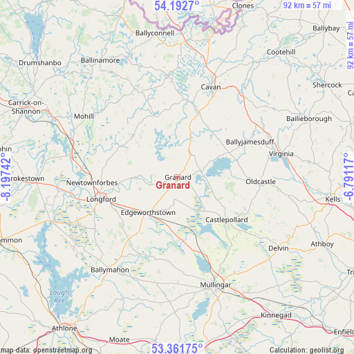
Granard GPS coordinates[2]
53° 46' 45.408" North, 7° 29' 39.444" West
| Map corner | latitude | longitude |
|---|---|---|
| Upper-left | 54.1927°, | -8.19742° |
| Center: | 53.77928°, | -7.49429° |
| Lower-right: | 53.36175°, | -6.79117° |
| Map W x H: | 92.4×92.4 km | = 57.4×57.4mi |
| max Lat: | 55.25° ⇑19.2% North |
| Granard: | 53.77928° |
| min Lat: | ⇓80.8% South 51.52487° |
| min Long | Granard | max Long |
| -10.26889° | -7.49429° | -6.04944° |
| W 47.6%⇐ | ⇒52.4% E |
Elevation
Elevation of Granard is 134 m = 440 ft, and this is 79.5 m = 261 ft above average elevation for this country.
| Max E: |
262 m = 860 ft | 3.8% |
| Granard | 134 m 440 ft | |
| Avg. | 54.5 m = 179 ft | |
Min E: |
0 m = 0 ft | 96.2% |
See also: Ireland elevation on elevation.city.
Geographical zone
Granard is located in North temperate zone (between Tropic of Cancer and the Arctic Circle). Distance of this North polar circle is 1421.5 km =883.3 mi to North.| Distance of | km | miles | from Granard |
|---|---|---|---|
| North Pole | 4027.4 | 2502.5 | to North |
| Arctic Circle | 1421.5 | 883.3 | to North |
| Tropic Cancer | 3373.8 | 2096.4 | to South |
| Equator | 5979.7 | 3715.6 | to South |


Nearby cities:
15 places around Granard: (largest is in red/bold)
• An Muileann gCearr
30.1 km =18.7 mi,  160°
160°
• Ballinagh
17.9 km =11.1 mi,  16°
16°
• Ballyjamesduff
21.4 km =13.3 mi,  63°
63°
• Ballymahon
29.7 km =18.5 mi,  217°
217°
• Castlepollard
17.1 km =10.6 mi,  130°
130°
• Cavan
25.1 km =15.6 mi, 20°
• Drumlish
18.4 km =11.4 mi,  283°
283°
• Edgeworthstown
11.9 km =7.4 mi, 222°
• Longford
20.9 km =13 mi,  253°
253°
• Moate
29.4 km =18.3 mi,  209°
209°
• Mohill
28.8 km =17.9 mi,  302°
302°
• Newtownforbes
22.3 km =13.9 mi,  266°
266°
• Oldcastle
21.8 km =13.5 mi,  93°
93°
• Roosky
28.4 km =17.6 mi, 282°
• Virginia
28.2 km =17.5 mi,  77°
77°
Sources, notices
• [Note1] Compared only with cities in Ireland existing in our database
• [Src1] Map data: © OpenStreetMap contributors (CC-BY-SA)
• [Src2] Other city data from geonames.org with taken over terms of usage.
• [Src3] Geographical zone / Annual Mean Temperature by Robert A. Rohde @ Wikipedia
