Ballylinan geodata
Ballylinan (Leinster) is a populated place; located in Ireland in Europe/Dublin (GMT+1) time zone. With population of 1,084 people, there are 335 cities with bigger population in this country. Compared to other cities in Ireland, 63% of cities are located further ↑North; 57.9% of cities are located further ←West and 75.3% of cities have lower elevation than Ballylinan. Note1


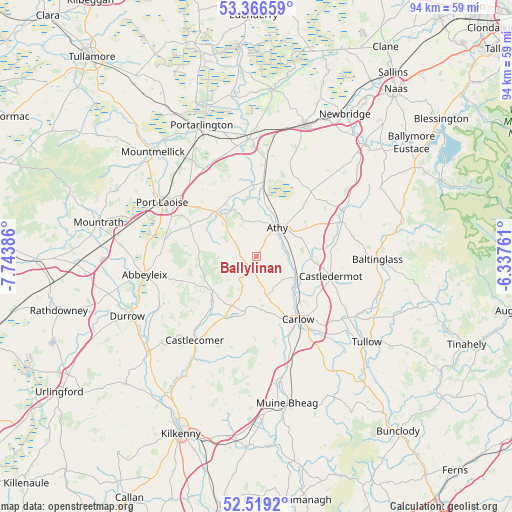
Ballylinan GPS coordinates[2]
52° 56' 41.892" North, 7° 2' 26.628" West
| Map corner | latitude | longitude |
|---|---|---|
| Upper-left | 53.36659°, | -7.74386° |
| Center: | 52.94497°, | -7.04073° |
| Lower-right: | 52.5192°, | -6.33761° |
| Map W x H: | 94.2×94.2 km | = 58.5×58.5mi |
| max Lat: | 55.25° ⇑63% North |
| Ballylinan: | 52.94497° |
| min Lat: | ⇓37% South 51.52487° |
| min Long | Ballylinan | max Long |
| -10.26889° | -7.04073° | -6.04944° |
| W 57.9%⇐ | ⇒42.1% E |
Elevation
Elevation of Ballylinan is 81 m = 266 ft, and this is 26.5 m = 87 ft above average elevation for this country.
| Max E: |
262 m = 860 ft | 24.7% |
| Ballylinan | 81 m 266 ft | |
| Avg. | 54.5 m = 179 ft | |
Min E: |
0 m = 0 ft | 75.3% |
See also: Ireland elevation on elevation.city.
Geographical zone
Ballylinan is located in North temperate zone (between Tropic of Cancer and the Arctic Circle). Distance of this North polar circle is 1514.2 km =940.9 mi to North.| Distance of | km | miles | from Ballylinan |
|---|---|---|---|
| North Pole | 4120.1 | 2560.1 | to North |
| Arctic Circle | 1514.2 | 940.9 | to North |
| Tropic Cancer | 3281 | 2038.7 | to South |
| Equator | 5886.9 | 3657.9 | to South |


Nearby cities:
15 places around Ballylinan: (largest is in red/bold)
• Abbeyleix
20.7 km =12.9 mi,  260°
260°
• Athy
6.6 km =4.1 mi,  38°
38°
• Ballitore
16.3 km =10.1 mi,  65°
65°
• Baltinglass
22.2 km =13.8 mi,  92°
92°
• Calverstown
22.3 km =13.9 mi,  46°
46°
• Carlow
13.9 km =8.6 mi,  146°
146°
• Castlecomer
19.2 km =11.9 mi,  216°
216°
• Castledermot
13.9 km =8.6 mi,  106°
106°
• Killenard
22.1 km =13.7 mi,  340°
340°
• Monasterevin
21.8 km =13.5 mi,  355°
355°
• Moneenroe
14 km =8.7 mi,  213°
213°
• Moone
15.5 km =9.6 mi,  77°
77°
• Portlaoise
20 km =12.4 mi,  299°
299°
• Stradbally
10.9 km =6.8 mi,  316°
316°
• Suncroft
21.4 km =13.3 mi,  34°
34°
Sources, notices
• [Note1] Compared only with cities in Ireland existing in our database
• [Src1] Map data: © OpenStreetMap contributors (CC-BY-SA)
• [Src2] Other city data from geonames.org with taken over terms of usage.
• [Src3] Geographical zone / Annual Mean Temperature by Robert A. Rohde @ Wikipedia
