Callan geodata
Callan (Leinster) is a populated place; located in Ireland in Europe/Dublin (GMT+1) time zone. With population of 2,330 people, there are 212 cities with bigger population in this country. Compared to other cities in Ireland, 78.2% of cities are located further ↑North; 50.3% of cities are located further ←West and 67.7% of cities have lower elevation than Callan. Note1


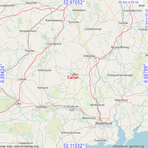
Callan GPS coordinates[2]
52° 32' 42" North, 7° 23' 27.996" West
| Map corner | latitude | longitude |
|---|---|---|
| Upper-left | 52.97052°, | -8.09424° |
| Center: | 52.545°, | -7.39111° |
| Lower-right: | 52.11532°, | -6.68799° |
| Map W x H: | 95.1×95.1 km | = 59.1×59.1mi |
| max Lat: | 55.25° ⇑78.2% North |
| Callan: | 52.545° |
| min Lat: | ⇓21.8% South 51.52487° |
| min Long | Callan | max Long |
| -10.26889° | -7.39111° | -6.04944° |
| W 50.3%⇐ | ⇒49.7% E |
Elevation
Elevation of Callan is 67 m = 220 ft, and this is 12.5 m = 41 ft above average elevation for this country.
| Max E: |
262 m = 860 ft | 32.3% |
| Callan | 67 m 220 ft | |
| Avg. | 54.5 m = 179 ft | |
Min E: |
0 m = 0 ft | 67.7% |
See also: Ireland elevation on elevation.city.
Geographical zone
Callan is located in North temperate zone (between Tropic of Cancer and the Arctic Circle). Distance of this North polar circle is 1558.7 km =968.5 mi to North.| Distance of | km | miles | from Callan |
|---|---|---|---|
| North Pole | 4164.6 | 2587.8 | to North |
| Arctic Circle | 1558.7 | 968.5 | to North |
| Tropic Cancer | 3236.5 | 2011.1 | to South |
| Equator | 5842.5 | 3630.4 | to South |


Nearby cities:
15 places around Callan: (largest is in red/bold)
• Ballyclerahan
28.9 km =18 mi,  239°
239°
• Ballyragget
27.4 km =17 mi,  8°
8°
• Bennettsbridge
15.2 km =9.4 mi,  69°
69°
• Carrick-on-Suir
21.8 km =13.5 mi,  183°
183°
• Fethard
22.1 km =13.7 mi,  246°
246°
• Freshford
21 km =13 mi,  358°
358°
• Gowran
23.4 km =14.5 mi, 66°
• Kilkenny
15.3 km =9.5 mi,  37°
37°
• Killenaule
19.1 km =11.9 mi,  277°
277°
• Kilsheelan
24.1 km =15 mi,  211°
211°
• Piltown
21.6 km =13.4 mi,  170°
170°
• Portlaw
28.9 km =18 mi, 170°
• Thomastown
17.3 km =10.7 mi,  96°
96°
• Twomileborris
26.3 km =16.3 mi,  302°
302°
• Urlingford
23.4 km =14.5 mi,  326°
326°
Sources, notices
• [Note1] Compared only with cities in Ireland existing in our database
• [Src1] Map data: © OpenStreetMap contributors (CC-BY-SA)
• [Src2] Other city data from geonames.org with taken over terms of usage.
• [Src3] Geographical zone / Annual Mean Temperature by Robert A. Rohde @ Wikipedia
