New Ross geodata
New Ross (Leinster) is a populated place; located in Ireland in Europe/Dublin (GMT+1) time zone. With population of 6,695 people, there are 103 cities with bigger population in this country. Compared to other cities in Ireland, 82.4% of cities are located further ↑North; 61.5% of cities are located further ←West and 51.6% of cities have lower elevation than New Ross. Note1


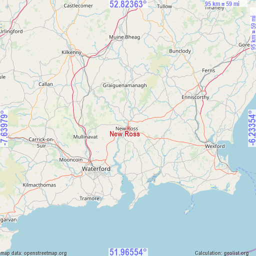
New Ross GPS coordinates[2]
52° 23' 48.012" North, 6° 56' 12.012" West
| Map corner | latitude | longitude |
|---|---|---|
| Upper-left | 52.82363°, | -7.63979° |
| Center: | 52.39667°, | -6.93667° |
| Lower-right: | 51.96554°, | -6.23354° |
| Map W x H: | 95.4×95.4 km | = 59.3×59.3mi |
| max Lat: | 55.25° ⇑82.4% North |
| New Ross: | 52.39667° |
| min Lat: | ⇓17.6% South 51.52487° |
| min Long | New Ross | max Long |
| -10.26889° | -6.93667° | -6.04944° |
| W 61.5%⇐ | ⇒38.5% E |
Elevation
Elevation of New Ross is 53 m = 174 ft, and this is 1.5 m = 5 ft below average elevation for this country.
| Max E: |
262 m = 860 ft | 48.4% |
| Avg. | 54.5 m = 179 ft | |
| New Ross | 53 m = 174 ft | |
Min E: |
0 m = 0 ft | 51.6% |
See also: Ireland elevation on elevation.city.
Geographical zone
New Ross is located in North temperate zone (between Tropic of Cancer and the Arctic Circle). Distance of this North polar circle is 1575.2 km =978.8 mi to North.| Distance of | km | miles | from New Ross |
|---|---|---|---|
| North Pole | 4181.1 | 2598 | to North |
| Arctic Circle | 1575.2 | 978.8 | to North |
| Tropic Cancer | 3220 | 2000.8 | to South |
| Equator | 5826 | 3620.1 | to South |


Nearby cities:
15 places around New Ross: (largest is in red/bold)
• Bennettsbridge
27.3 km =17 mi,  322°
322°
• Borris
22.6 km =14 mi,  3°
3°
• Dunmore East
27.6 km =17.1 mi,  188°
188°
• Enniscorthy
28.2 km =17.5 mi,  65°
65°
• Gowran
27.5 km =17.1 mi,  340°
340°
• Graiguenamanagh
16 km =9.9 mi,  355°
355°
• Kilmacow
18.6 km =11.6 mi,  241°
241°
• Mooncoin
24.3 km =15.1 mi, 240°
• Passage East
18.6 km =11.6 mi, 187°
• Piltown
27.8 km =17.3 mi,  260°
260°
• Portlaw
28.7 km =17.8 mi,  245°
245°
• Taghmon
21.3 km =13.2 mi,  113°
113°
• Thomastown
19.8 km =12.3 mi, 316°
• Trá Mhór
29.9 km =18.6 mi,  209°
209°
• Waterford
19.5 km =12.1 mi,  217°
217°
Sources, notices
• [Note1] Compared only with cities in Ireland existing in our database
• [Src1] Map data: © OpenStreetMap contributors (CC-BY-SA)
• [Src2] Other city data from geonames.org with taken over terms of usage.
• [Src3] Geographical zone / Annual Mean Temperature by Robert A. Rohde @ Wikipedia
