Ferbane geodata
Ferbane (Leinster) is a populated place; located in Ireland in Europe/Dublin (GMT+1) time zone. With population of 1,165 people, there are 319 cities with bigger population in this country. Compared to other cities in Ireland, 50.3% of cities are located further ↓South; 59.4% of cities are located further →East and 54.5% of cities have higher elevation than Ferbane. Note1


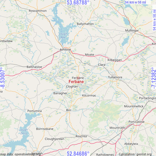
Ferbane GPS coordinates[2]
53° 16' 9.984" North, 7° 49' 36.984" West
| Map corner | latitude | longitude |
|---|---|---|
| Upper-left | 53.68788°, | -8.53007° |
| Center: | 53.26944°, | -7.82694° |
| Lower-right: | 52.84686°, | -7.12382° |
| Map W x H: | 93.5×93.5 km | = 58.1×58.1mi |
| max Lat: | 55.25° ⇑49.7% North |
| Ferbane: | 53.26944° |
| min Lat: | ⇓50.3% South 51.52487° |
| min Long | Ferbane | max Long |
| -10.26889° | -7.82694° | -6.04944° |
| W 40.6%⇐ | ⇒59.4% E |
Elevation
Elevation of Ferbane is 44 m = 144 ft, and this is 10.5 m = 34 ft below average elevation for this country.
| Max E: |
262 m = 860 ft | 54.5% |
| Avg. | 54.5 m = 179 ft | |
| Ferbane | 44 m = 144 ft | |
Min E: |
0 m = 0 ft | 45.5% |
See also: Ireland elevation on elevation.city.
Geographical zone
Ferbane is located in North temperate zone (between Tropic of Cancer and the Arctic Circle). Distance of this North polar circle is 1478.2 km =918.5 mi to North.| Distance of | km | miles | from Ferbane |
|---|---|---|---|
| North Pole | 4084.1 | 2537.7 | to North |
| Arctic Circle | 1478.2 | 918.5 | to North |
| Tropic Cancer | 3317.1 | 2061.1 | to South |
| Equator | 5923 | 3680.4 | to South |


Nearby cities:
15 places around Ferbane: (largest is in red/bold)
• Athlone
20 km =12.4 mi,  335°
335°
• Ballinasloe
26.9 km =16.7 mi,  283°
283°
• Banagher
13.9 km =8.6 mi,  229°
229°
• Birr
20.6 km =12.8 mi,  196°
196°
• Clara
16.3 km =10.1 mi,  60°
60°
• Cloghan
6.5 km =4 mi,  215°
215°
• Clonaslee
24.3 km =15.1 mi,  123°
123°
• Kilbeggan
24.2 km =15 mi, 62°
• Kilcormac
12.6 km =7.8 mi,  147°
147°
• Moate
15.6 km =9.7 mi,  27°
27°
• Moate
32 km =19.9 mi,  13°
13°
• Portumna
32.9 km =20.4 mi, 232°
• Shinrone
32.6 km =20.3 mi,  191°
191°
• Tullamore
22.5 km =14 mi,  88°
88°
• Tyrrellspass
32.9 km =20.4 mi,  66°
66°
Sources, notices
• [Note1] Compared only with cities in Ireland existing in our database
• [Src1] Map data: © OpenStreetMap contributors (CC-BY-SA)
• [Src2] Other city data from geonames.org with taken over terms of usage.
• [Src3] Geographical zone / Annual Mean Temperature by Robert A. Rohde @ Wikipedia
