Banagher geodata
Banagher (Leinster) is a populated place; located in Ireland in Europe/Dublin (GMT+1) time zone. With population of 1,653 people, there are 256 cities with bigger population in this country. Compared to other cities in Ireland, 53.7% of cities are located further ↑North; 62.6% of cities are located further →East and 52.9% of cities have higher elevation than Banagher. Note1


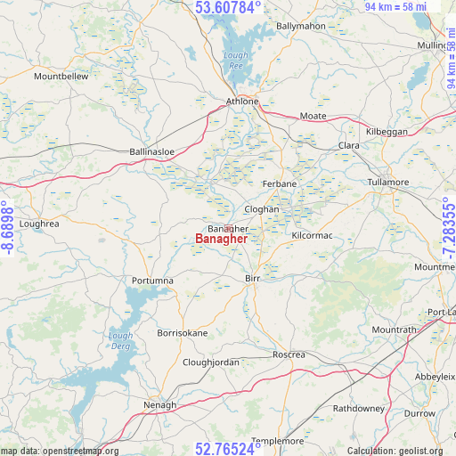
Banagher GPS coordinates[2]
53° 11' 18.996" North, 7° 59' 12.012" West
| Map corner | latitude | longitude |
|---|---|---|
| Upper-left | 53.60784°, | -8.6898° |
| Center: | 53.18861°, | -7.98667° |
| Lower-right: | 52.76524°, | -7.28355° |
| Map W x H: | 93.7×93.7 km | = 58.2×58.2mi |
| max Lat: | 55.25° ⇑53.7% North |
| Banagher: | 53.18861° |
| min Lat: | ⇓46.3% South 51.52487° |
| min Long | Banagher | max Long |
| -10.26889° | -7.98667° | -6.04944° |
| W 37.4%⇐ | ⇒62.6% E |
Elevation
Elevation of Banagher is 47 m = 154 ft, and this is 7.5 m = 25 ft below average elevation for this country.
| Max E: |
262 m = 860 ft | 52.9% |
| Avg. | 54.5 m = 179 ft | |
| Banagher | 47 m = 154 ft | |
Min E: |
0 m = 0 ft | 47.1% |
See also: Ireland elevation on elevation.city.
Geographical zone
Banagher is located in North temperate zone (between Tropic of Cancer and the Arctic Circle). Distance of this North polar circle is 1487.2 km =924.1 mi to North.| Distance of | km | miles | from Banagher |
|---|---|---|---|
| North Pole | 4093 | 2543.3 | to North |
| Arctic Circle | 1487.2 | 924.1 | to North |
| Tropic Cancer | 3308.1 | 2055.6 | to South |
| Equator | 5914 | 3674.8 | to South |


Nearby cities:
15 places around Banagher: (largest is in red/bold)
• Athlone
27.3 km =17 mi,  5°
5°
• Ballinasloe
21.9 km =13.6 mi,  314°
314°
• Birr
11.9 km =7.4 mi,  155°
155°
• Borrisokane
23.5 km =14.6 mi,  203°
203°
• Clara
30.1 km =18.7 mi,  55°
55°
• Cloghan
7.8 km =4.8 mi, 61°
• Clonaslee
31.1 km =19.3 mi,  98°
98°
• Cloughjordan
27.8 km =17.3 mi,  186°
186°
• Ferbane
13.9 km =8.6 mi,  49°
49°
• Kilcormac
17.5 km =10.9 mi, 95°
• Moate
29 km =18 mi,  38°
38°
• Portumna
19 km =11.8 mi,  234°
234°
• Roscrea
29.2 km =18.1 mi,  154°
154°
• Shinrone
23.3 km =14.5 mi,  169°
169°
• Tullamore
34.5 km =21.4 mi,  74°
74°
Sources, notices
• [Note1] Compared only with cities in Ireland existing in our database
• [Src1] Map data: © OpenStreetMap contributors (CC-BY-SA)
• [Src2] Other city data from geonames.org with taken over terms of usage.
• [Src3] Geographical zone / Annual Mean Temperature by Robert A. Rohde @ Wikipedia
