Shinrone geodata
Shinrone (Leinster) is a populated place; located in Ireland in Europe/Dublin (GMT+1) time zone. With population of 634 people, there are 461 cities with bigger population in this country. Compared to other cities in Ireland, 61.9% of cities are located further ↑North; 61.9% of cities are located further →East and 68.3% of cities have lower elevation than Shinrone. Note1


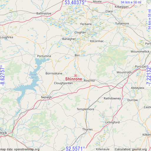
Shinrone GPS coordinates[2]
52° 58' 57" North, 7° 55' 27.984" West
| Map corner | latitude | longitude |
|---|---|---|
| Upper-left | 53.40375°, | -8.62757° |
| Center: | 52.9825°, | -7.92444° |
| Lower-right: | 52.5571°, | -7.22132° |
| Map W x H: | 94.1×94.1 km | = 58.5×58.5mi |
| max Lat: | 55.25° ⇑61.9% North |
| Shinrone: | 52.9825° |
| min Lat: | ⇓38.1% South 51.52487° |
| min Long | Shinrone | max Long |
| -10.26889° | -7.92444° | -6.04944° |
| W 38.1%⇐ | ⇒61.9% E |
Elevation
Elevation of Shinrone is 68 m = 223 ft, and this is 13.5 m = 44 ft above average elevation for this country.
| Max E: |
262 m = 860 ft | 31.7% |
| Shinrone | 68 m 223 ft | |
| Avg. | 54.5 m = 179 ft | |
Min E: |
0 m = 0 ft | 68.3% |
See also: Ireland elevation on elevation.city.
Geographical zone
Shinrone is located in North temperate zone (between Tropic of Cancer and the Arctic Circle). Distance of this North polar circle is 1510.1 km =938.3 mi to North.| Distance of | km | miles | from Shinrone |
|---|---|---|---|
| North Pole | 4116 | 2557.6 | to North |
| Arctic Circle | 1510.1 | 938.3 | to North |
| Tropic Cancer | 3285.2 | 2041.3 | to South |
| Equator | 5891.1 | 3660.6 | to South |


Nearby cities:
15 places around Shinrone: (largest is in red/bold)
• Banagher
23.3 km =14.5 mi,  349°
349°
• Birr
12.1 km =7.5 mi,  3°
3°
• Borrisokane
13.7 km =8.5 mi,  275°
275°
• Borrisoleigh
25.7 km =16 mi,  184°
184°
• Cloghan
26.7 km =16.6 mi,  5°
5°
• Clonaslee
32.4 km =20.1 mi,  55°
55°
• Cloughjordan
8.8 km =5.5 mi,  237°
237°
• Kilcormac
25.1 km =15.6 mi,  31°
31°
• Mountrath
30.3 km =18.8 mi,  86°
86°
• Nenagh
22.6 km =14 mi,  233°
233°
• Nenagh Bridge
21.4 km =13.3 mi, 238°
• Portumna
23 km =14.3 mi,  301°
301°
• Rathdowney
27.1 km =16.8 mi,  121°
121°
• Roscrea
8.9 km =5.5 mi,  113°
113°
• Templemore
21.7 km =13.5 mi,  163°
163°
Sources, notices
• [Note1] Compared only with cities in Ireland existing in our database
• [Src1] Map data: © OpenStreetMap contributors (CC-BY-SA)
• [Src2] Other city data from geonames.org with taken over terms of usage.
• [Src3] Geographical zone / Annual Mean Temperature by Robert A. Rohde @ Wikipedia
